DOI:
https://doi.org/10.14483/22487638.17882Published:
2023-10-11Issue:
Vol. 27 No. 77 (2023): Julio - SeptiembreSection:
ResearchLandslides in Tijuana, Mexico: hazard assessment in an urban neighborhood
Deslizamientos de tierra en Tijuana, México: evaluación de la amenaza en un barrio de la zona urbana
Keywords:
deslizamiento, riesgo por deslizamiento, deslizamientos urbanos, evaluación del riesgo (es).Keywords:
landslides, landslide hazard, urban landslides, hazard assessment (en).Downloads
References
Abhirup D., Raju S., Biswajeet P., Ratiranjan J., Dowchu D. and Abdullah M. A. (2020). Temporal Probability Assessment and Its Use in Landslide Susceptibility Mapping for Eastern Bhutan, Water, 12, 267, http://dx.doi.org/10.3390/w12010267 DOI: https://doi.org/10.3390/w12010267
Acosta-Chang, J. G., Zepeda, G., Ruiz, E. (2009). Microzonificación sísmica de Tijuana, Informe final, CICESE. Brenning A. (2005). Spatial prediction models for landslide hazards: review, comparison and evaluation, Nat Hazards Earth Syst Sci, 5, 853–862, https://doi.org/10.5194/ nhess-5-853-2005 DOI: https://doi.org/10.5194/nhess-5-853-2005
Catani, F., Lagomarsino, D., Segoni, S., Tofani, V. (2013). Landslide susceptibility estimation by random forests technique: sensitivity and scaling issues, Nat Hazards Earth Syst Sci, 13, 2815–2831, https://doi.org/10.5194/nhess-13-2815-2013 DOI: https://doi.org/10.5194/nhess-13-2815-2013
Crovelli, R. A. (2000). Probability models for estimation of number and costs of landslides, (Open File Report 00-249). United States Geological Survey https://doi.org/10.3133/ofr00249 Cruz-Castillo, M. (2002). Catálogo de las fallas regionales activas en el norte de Baja California, México, GEOS, Unión Geofísica Mexicana, A.C., 37– 41. DOI: https://doi.org/10.3133/ofr00249
Cuanalo, O. A., Oliva, A. O., González, C. (2007). Estabilidad de laderas. Análisis mediante factores de valuación, Revista IngeoPres, 164, 38–44.
Escalante T., J.O.; Cáceres J., J.J. y Porras D., H. (2016). Orthomosaics and digital elevation models generated from images taken with UAV systems. Tecnura, 20(50), 119-140. https://doi.org/10.14483/udistrital.jour.tecnura.2016.4.a09 DOI: https://doi.org/10.14483/udistrital.jour.tecnura.2016.1.a10
Fell, R., Corominas, J., Bonnard, C., Cascini, L., Leroi, E., Savage, W. (2008). On behalf of the JTC-1 Joint Technical Committee on Landslides and Engineered Slopes, Guidelines for landslide susceptibility, hazard and risk zoning for land-use planning, Engineering Geology, 102, 85-98 and commentary on 99-111, http://dx.doi.org/10.1016/j.enggeo.2008.03.022 DOI: https://doi.org/10.1016/j.enggeo.2008.03.022
Guzzetti, F., Reichenbach, P., Cardinali, M., Galli, M., and Ardizzone, F. (2005). Probabilistic andslide hazard assessment at the basin scale, Geomorphology, 72, 272–299, https://doi.org/10.1016/j.geomorph.2005.06.002 DOI: https://doi.org/10.1016/j.geomorph.2005.06.002
Guzzetti, F., Galli, M., Reichenbach, P., Ardizzone, F., and Cardinali, M. (2006). Landslide hazard assessment in the Collazzone area, Umbria, Central Italy, Nat. Hazards Earth Syst. Sci., 6, 115–131, https://doi.org/10.5194/nhess-6-115-2006 DOI: https://doi.org/10.5194/nhess-6-115-2006
Guzzetti, F., Mondini, A. C., Cardinali, M., Fiorucci, F., Santangelo, M., and Chang, K.-T. (2012). Landslide inventory maps: New tools for an old problem, Earth-Sci. Rev., 112, 42–66, https: //doi.org/10.1016/j.earscirev.2012.02.001 DOI: https://doi.org/10.1016/j.earscirev.2012.02.001
Hungr, O. (1997). Some methods of landslide hazard intensity mapping. In Cruden & Fell (eds) Landslide Risk Assessment, Balkema, 215-226. DOI: https://doi.org/10.1201/9780203749524-12
Malamud, B. D., Turcotte, D. L., Guzzetti, F., and Reichenbach, P. (2004). Landslide inventories and their statistical properties, Earth Surface Processes and Landforms, 29(6), 687–711, https: //doi.org/10.1002/esp.1064 DOI: https://doi.org/10.1002/esp.1064
Mavrouli, O., Corominas, J., Ibarbia, I., Alonso, N., Jugo, I., Ruiz, J., Luzuriaga, S., and Navarro, J. A. (2019). Integrated risk assessment due to slope instabilities in the roadway network f Gipuzkoa, Basque Country, Nat. Hazards Earth Syst. Sci., 19, 399–419, https://doi.org/10.5194/nhess-19-399-2019 DOI: https://doi.org/10.5194/nhess-19-399-2019
NTC. (2017). Normas Técnicas Complementarias de la Ley de Edificaciones del Estado de Baja California, Seguridad Estructural en materia de Diseño Sísmico, SIDURT, Estado de Baja California, México.
Sheng F., Lixia Ch., Tsehaie W., Kunlong Y., Lei G., Deying L., Juan D., Chao Z., Yong X., and Zhipeng L. (2020). Landslide hazard probability and risk assessment at the community level: a case of western Hubei, China, Nat. Hazards Earth Syst. Sci., 20, 581–601, https://doi.org/10.5194/nhess-20-581-2020 DOI: https://doi.org/10.5194/nhess-20-581-2020
Silva, M.; T. William Lambe, Hon. M.; and W. Allen Marr, F. (2008). Probability and Risk of Slope Failure, Journal of Geotechnical and Geoenvironmental Engineering, 134(12), https://ascelibrary.org/doi/10.1061/%28ASCE%291090-0241%282008%29134%3A12%281691%29
SLOPE/W. (2012). Stability Modeling with SLOPE/W, An Engineering Methodology, July edition, GEO_SLOPE International.
Stark, C. P. and Hovius, N. (2001). The characterization of landslide size distributions, Geophys. Res. Lett., 28(6), 1091–1094, https://doi.org/10.1029/2000GL008527 DOI: https://doi.org/10.1029/2000GL008527
Oliva, A. O., Mascareño, D., Álvarez I. N., González, C. and Álvarez A. E. (2014). Hillside instability in the Tijuana metropolitan area. Analysis of landslide-provoked building collapse. Engineering Failure Analysis, 46, 166–178. https://doi.org/10.1016/j.engfailanal.2014.08.004 DOI: https://doi.org/10.1016/j.engfailanal.2014.08.004
Oliva G., y Gallardo A., R. J. (2018). Evaluación del Riesgo por Deslizamiento de una Ladera en la Ciudad de Tijuana, Mexico. Revista Tecnura, 22(55), 34-50. https://doi.org/10.14483/22487638.12063 DOI: https://doi.org/10.14483/22487638.12063
Oliva-González, A. O., Ruiz-Pozo, A. F., Gallardo-Amaya, R. J. and Jaramillo, H. Y. (2019). Landslide risk assessment in slopes and hillsides. Methodology and application in a realase, DYNA, 86(208), 143 – 152, http://doi.org/10.15446/dyna.v86n208.72341 DOI: https://doi.org/10.15446/dyna.v86n208.72341
Oliva, A. O., Berumen, M. A., Gallardo, R. J. and Jaramillo, H. Y. (2019). Terrain instability in the Tijuana metropolitan area: Analysis of a failure in the access road to an industrial park, Engineering Failure Analysis, 104, 354-370. https://doi.org/10.1016/j.engfailanal.2019.05.040 DOI: https://doi.org/10.1016/j.engfailanal.2019.05.040
Parra Ortega, C. A., Quintana-Cabeza, C., Mosquera-Téllez, J. (2022). Modeling of Mass Movement Phenomena to Determine the Depth of Rainfall Infiltration into the Soil. Tecnura, 26(72), 78–102. https://doi.org/10.14483/22487638.17743 DOI: https://doi.org/10.14483/22487638.17743
Reichenbach, P., Rossi, M., Malamud, B.D., Mihir, M., Guzzetti, F. (2018). A review of statistically based landslide susceptibility models, Earth-Sci. Rev., 180, 60–91, https://doi.org/0.1016/j.earscirev.2018.03.001 DOI: https://doi.org/10.1016/j.earscirev.2018.03.001
Qiao, S., Qin, S., Chen, J., Hu, X., and Ma, Z. (2019). The Application of a Three-Dimensional Deterministic Model in the Study of Debris Flow Prediction Based on the RainfallUnstable Soil Coupling Mechanism, Processes, 7, 99, https://doi.org/10.3390/pr7020099 DOI: https://doi.org/10.3390/pr7020099
UN-ISDR. (2004). Living with risk: a global review of disaster reduction initiatives. United Nations Office for Disaster Risk Reduction, https://www.undrr.org/publication/living-risk-global-review-disaster-reduction-initiatives
Van Westen, C. J., Castellanos, E., and Kuriakose, S. L. (2008). Spatial data for landslide susceptibility, hazard, and vulnerability assessment: An overview, Eng. Geol., 102, 112–131, https://doi.org/10.1016/j.enggeo.2008.03.010 DOI: https://doi.org/10.1016/j.enggeo.2008.03.010
Van Westen, C. J., Alkema, D., Damen, M. C. J., Kerle, N., and Kingma, N. C. (2011). Multihazard risk assessment distance education course, Guide book. United Nations University – ITC School on Disaster Geoinformation
How to Cite
APA
ACM
ACS
ABNT
Chicago
Harvard
IEEE
MLA
Turabian
Vancouver
Download Citation
Recibido: 18 de abril de 2021; Aceptado: 7 de marzo de 2022
Abstract
Context:
Landslides in Tijuana, Mexico, destroy a large number of structures and infrastructures each year, producing large losses in various economic sectors.
Method:
In this study, we carry out a quantitative assessment of the hazards of landslides in a Tijuana neighborhood that was affected by a landslide in 2010 and currently shows signs of terrain instability, raising concerns about potential future landslides. The hazard assessment was calculated using the spatial probability, based on how susceptible the terrain was to landslides, and the temporal probability using a database of events that occurred at sites near te study area. We apply deterministic methods based on the analysis of slope stability to calculate susceptibility and estimate the temporal probability using probability models that consider the instances of independent random events.
Results:
It was found that more than 50 % of the studied area presents a high hazard of landslides for return periods of 5, 10, 15, and 20 years. Moreover, findings demonstrated that the seismicity, topography, and the geotechnical characteristics of the soils are the factors with major influence on ground instability. In addition, it was determined that the areas of potential landslides are in soils whose resistance has been reduced due to the presence of underground flows produced by the infiltration of water through existing cracks and fractures in the terrain.
Conclusions:
The application of the described procedure made it possible to quantify the hazards of landslides in the Laderas de Monterrey neighborhood for four return periods and to determine the factors that most influence the occurrences of these phenomena. The results obtained are an important step to analyze and evaluate the risk that landslides represent for structures, infrastructures, and people exposed to the impact of these phenomena. They are also a valuable tool for making informed decisions regarding risk management and the establishment of regulations on land use.
Keywords:
landslides, landslide hazard, urban landslides, hazard assessment.Resumen
Contexto:
Los deslizamientos de tierra en Tijuana, México, provocan cada año la destrucción de una gran cantidad de estructuras e infraestructuras, produciendo cuantiosas pérdidas en diversos sectores de la economía.
Método:
En este estudio, se realiza una evaluación cuantitativa del peligro de deslizamientos de tierra en un barrio de la ciudad de Tijuana, el cual fue afectado por un deslizamiento en el año 2010 y actualmente presenta indicios de inestabilidad del terreno, alertando sobre la posibilidad de que ocurran nuevos deslizamientos. La amenaza fue calculada utilizando la probabilidad espacial, a partir de la susceptibilidad del terreno a los deslizamientos de tierra, y la probabilidad temporal se calculó utilizando una base de datos de eventos ocurridos en sitios cercanos al área de estudio. Se aplicaron métodos determinísticos basados en el análisis de estabilidad de taludes para calcular la susceptibilidad del terreno y se estimó la probabilidad temporal utilizando modelos de probabilidad que consideran la ocurrencia de eventos aleatorios independientes.
Resultados:
Se encontró que más del 50 % del área de estudio presenta una alta amenaza de deslizamientos de tierra para períodos de retorno de 5, 10, 15 y 20 años. Se comprobó además que la sismicidad, la topografía y las propiedades geotécnicas de los suelos son los factores que más influyen en la inestabilidad del terreno. Adicionalmente, se determinó que las áreas de potenciales deslizamientos de tierra se encuentran en suelos cuya resistencia se ha reducido debido a la presencia de flujos subterráneos producidos por el movimiento de agua a través de grietas y fracturas existentes en el terreno.
Conclusiones:
La aplicación del procedimiento descrito permitió cuantificar la amenaza de deslizamientos de tierra en el barrio estudiado para cuatro períodos de retorno. También permitió identificar los factores que más influyen en la ocurrencia de estos fenómenos. Los resultados obtenidos son un paso importante para analizar y evaluar el riesgo que representan los deslizamientos de tierra para las estructuras, infraestructuras y personas expuestas al impacto de estos fenómenos; y son una valiosa herramienta para tomar decisiones relacionadas con la gestión del riesgo y el establecimiento de regulaciones sobre el uso de suelo.
Palabras clave:
deslizamientos de tierra, amenaza de deslizamientos, deslizamientos urbanos, evaluación de amenaza.INTRODUCTION
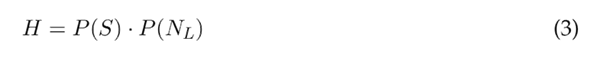
In general, a hazard is a potentially harmful physical event or human activity that can cause loss of life, property damage, economic and social disruption, and environmental degradation (UN-ISDR, 2004). In the case of landslides, the event has a certain probability of occurrence within a specific period of time, in an established area, and with a determined intensity (Van Westen et al., 2011). This probability can be calculated using the following equation (Guzzetti et al., 2006):

Here, H expresses the hazard probability, P (S) the probability of landslide spatial occurrence based on the local environmental setting, P (N L ) a probability of landslide occurrence within an established period, and P (A L ) denotates the probability of landslide size.
Landslides spatial probability
Landslides spatial probability is based on the concept of landslides susceptibility and refers to the classification, area, volume, and distribution in space of events that occurred or may occur within a designated study area. The methods for assessing landslides susceptibility are classified into qualitative and quantitative approaches. Qualitative susceptibility assessment is carried out based on a compilation of landslides data, relying on geomorphological maps, parameters, and indices, and it requires the analysis of experts. These methods are widely used (Fell et al., 2008; Van Westen et al., 2008; Guzzetti et al., 2012; Sheng et al., 2020). In the quantification of landslides susceptibility, prominent methods include data processing (statistical) techniques and deterministic analysis. Data-driven analyses involve the statistical evaluation of combined factors that have produced landslides in the past, resulting in quantitative predictions for areas with similar conditions where landslides have not occurred. These methods assume that the conditions that led to landslides in the past will continue to do so in the future, and as a result, they are widely used (Guzzetti et al., 2005; Brenning, 2005; Catani et al., 2013; Reichenbach et al., 2018; Abhirup et al., 2020). Deterministic methods model and simulate landslide processes using models based on slope stability analysis (Silva et al., 2008; Oliva & Gallardo, 2018; Oliva-González et al., 2019; Mavrouli et al., 2019; Quiau et al., 2019; Parra et al., 2022). These methods are applicable only when there is enough topographic, geological, and hydrological data available to develop an adequate geotechnical database for the study area.
Landslide temporal probability
Although landslides are events that do not follow a particular probability model, their frequency of occurrence can be estimated using different methods. When detailed multitemporal landslide inventory maps are available, the temporal probability of landslides can be estimated through the analysis of the empirical recurrence of slope failures (Guzzetti et al., 2006), using statistical or heuristic methods. The resulting classes are then associated with the temporal probability of the triggering events (Van Westen et al., 2011). Some authors have established, through expert judgment, relationships between the factor of safety to the landslide and the annual probability of slope failures (Silva et al., 2008).
When there is no multitemporal inventory of landslides or maps linking landslides with their triggering events, the temporal probability can be evaluated using probabilistic models that consider the occurrence of independent random events in the time (Crovelli, 2000; Guzzetti et al., 2006; Sheng et al., 2020).
Probability of landslide size
The probability of landslide size is calculated by observing the relationship between the volume of landslides and their cumulative frequency, using the information obtained from the multitemporal landslide inventories that exist for the study area. To determine the probability densities, the double Pareto and inverse Gamma distributions are widely employed (Stark & Hovius, 2001; Malamud et al., 2004; Guzzetti et al., 2006) but some authors have used distributions obtained through the use of the ordinary least squares method (Sheng et al., 2020).
Landslides in Tijuana urban área
On average, in the urban area of Tijuana, Mexico, more than two landslides occur per year. These phenomena produce direct and indirect adverse effects on physical infrastructure, lifelines, and people, causing chaos, suffering, and a sense of helplessness wthin the affected communities, as well as large material losses in various economic sectors (Figure 1). Due to their frequency and magnitude, these events themselves constitute emergencies, the effective management of which poses growing challenges for authorities. Furthermore, they negatively impact the socio-economic structure of the municipality.
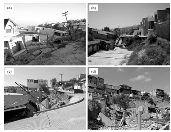
Figure 1. ): Some urban landslides occurred in Tijuana. Note. (a Lomas Conjunto Residencial Landslide, 2009; (b) Laderas de Monterrey Landslide, 2010; (c) Liberal Lomas del Rubí Landslide, 2018; (d) Cumbres del Rubí Landslide, 2019.
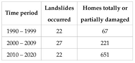
From 1990 to September 2020, more than seventy landslides have been registered in the urban area of Tijuana. These incidents have resulted in the complete or partial destruction of over a thousand buildings, mainly homes, along with extensive damage to essential infrastructure such as road networks, electricity, drinking water, and drainage (Table 1).
Source: authors.
Table 1: Summary of landslides that occurred in Tijuana urban area from January 1990 to September 2020, and their impacts on homes.
The Tijuana city was built on terrain with complex geological, geomorphological, and hydrological characteristics, situated within a region of great seismic activity. These factors were not adequately considered during urban planning, leading to a rapid and haphazard expansion of the city. Consequently, the city spread into hillside areas potentially unstable, as well as soils and fillings affected by previous landslides (Oliva et al., 2019). The main objective of this study is to assess the hazard landslides in a neighborhood of the Tijuana city, using deterministic methods based on slope stability models and probabilistic methods based on landslides that occurred in nearby sites with similar characteristics.
METHODOLOGY
This section describes the study area and presents a summary of the methods used to quantify the landslides hazard in the studied neighborhood.
Study area and data
The study area encompasses the Laderas de Monterrey neighborhood (32 ° 30’25.29 "N 117 ° 1’27.23"W), located in the center of the Tijuana urban area. The urbanized area of the neighborhood occupies an area of approximately 62,000 m2 and was built in the 1990s on land characterized by its irregular topography. The neighborhood’s buildings are individual homes averaging two levels in height and more than 150 m2 of the living area each. On May 3rd of 2010, a landslide occurred in this neighborhood destroying a total of eleven homes and causing significant damage to another eight. In addition, the road network and public services were seriously affected by the destruction of three streets and damage to the drinking water, electricity, and drainage networks (Figure 2).
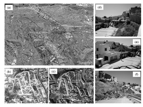
Figure 2. (a): Laderas de Monterrey neighborhood before and after the landslide. Note. Location of the neighborhood in the urban area; (b) neighborhood in 2006; (c) neighborhood in 2019; (d) main escarp, (e) body and (f) foot of the landslide.
The study area was selected because it was affected by the 2010 landslide and because it currently shows signs of geotechnical and structural pathologies which are evidence of terrain instability and warn of the possibility of new landslides, increasing concerns about the dangers that these phenomena pose for at least 46 homes and the more than 163 residents of the neighborhood. From the analysis and interpretation of the results of different studies and investigations carried out in the area from 2010 to date, data, parameters, and information related to the topography, geomorphology, geology, geotechnics, and hydrology of the study area were obtained.
Topography and geomorphology
The study area is located on a hill cut by erosion channels, indicative of the land’s susceptibility to physical and morphological transformations. The neighborhood has been established on a hillside with an average slope of 39 % that is part of the tributary micro-basins of the La Piedrera creek. Figure 3 shows the geomorphology of the site and the digital terrain elevation model obtained using UVA system (Escalante, 2016).
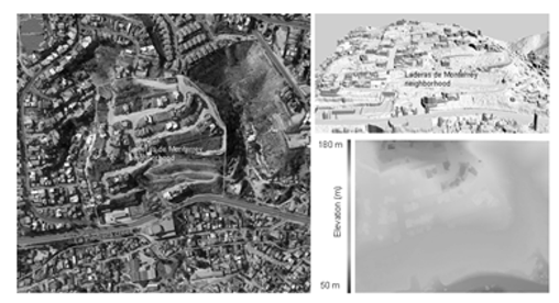
Figure 3: Topography and geomorphology of the study area.
Geology and geotechnics
At the base of the hillside, there is the typical lithology of the Otay Geological Formation, made up of medium-grained and light-gray color tobaceous sandstones; while in the upper part of the outcrop, the lithology is that of the San Diego Geological Formation, which is characterized by clayey sands with intercalations of boulders, gravel, and thin layers of clay. Recent geotechnical and geophysical studies indicate the presence of significant amounts of soft, low-strength materials, products of the collapse and removal of the natural terrain due to the landslide in 2010 and as a result of the deterioration of the surface soils and fillings due to weathering (Figure 4).
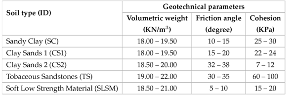
Table 2 shows the geotechnical parameters of the terrain, obtained with field and laboratory tests.
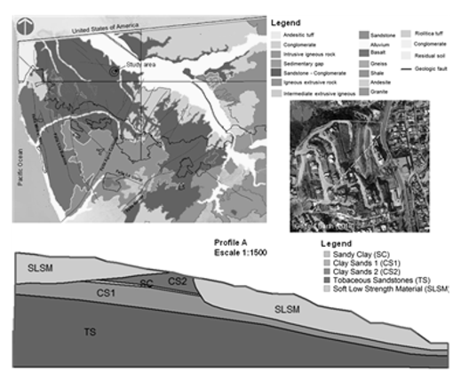
Figure 4: General stratigraphy of the study area.
Source: authors.
Table 2: Properties of the predominant soils in the study area.
Seismic activity
In the study area, as in the entire city of Tijuana, the tectonic framework is characterized by the faults that cross the peninsular mountain ranges whose activity directly affects the urban area (Hungr, 1997; Cruz-Castillo, 2002). Studies carried out indicate that one of the triggers for the 2010 landslide was the 7.2 magnitude earthquake that occurred on April 4 of that year (a month earlier), with its epicenter in the Mexicali Valley, 159 km from Tijuana (Oliva et al., 2014).
Hydrology and hydrogeology
The rains in the region are scarce and there are no permanent flows of surface water. However, small flows of underground water were detected by employing onshore geotechnical investigation surveys and geophysical exploration. The flows originate in the upper part of the hillside and roughly follow the path of the bed of an old creek that was filled during the construction of the neighborhood.
Procedure to assess risk
The probability of landslides size was not considered in the calculation of the risk because there is no detailed inventory of landslides that occurred in the area where the neighborhood is located. However, records of landslides that occurred in nearby sites, as well as the topographic, geomorphological, geological, and hydrological studies carried out, provide sufficient data and geotechnical parameters to assess the risk using deterministic methods based on slope stability models. The general scheme of the methodology used is presented in Figure 5.
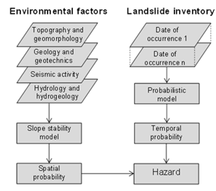
Figure 5: Scheme of the methodology used.
Spatial probability
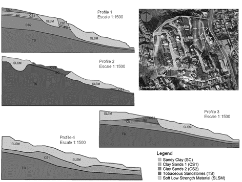
The spatial probability was analyzed from the concept of susceptibility to landslides and was calculated using slope stability analysis methods, through which potential landslide surfaces and their corresponding factors of safety were obtained. The stability analyses were carried out in four profiles of the study area (Figure 6), which were selected considering the geometry of the terrain surface, the presence of groundwater flows and anomalies in the subsoil, as well as the geotechnical and structural pathologies associated with processes of terrain instability.
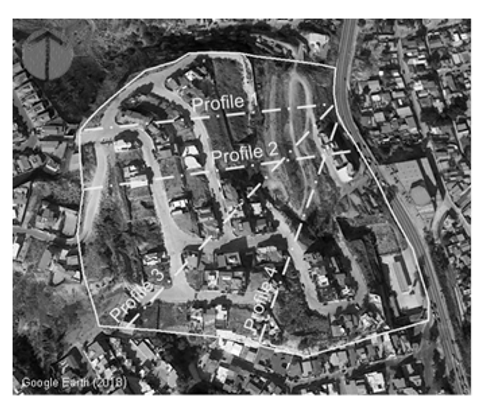
Figure 6: Profiles used for slope stability analysis.
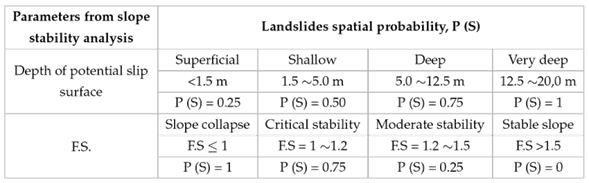
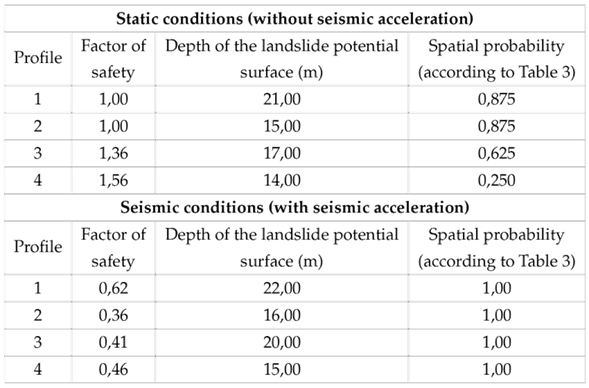
The relationships used to estimate the spatial probability from the depth of the potential slip surface and its corresponding factor of safety (F.S) are presented in Table 3.
Source: modified from Cuanalo et al., 2007.
Table 3: Landslides spatial probability
Temporal probability
Temporal probability was estimated considering that the failures in the slopes are independent random events in time. The Poisson model was adopted (Crovelli, 2000; Sheng et al., 2020) which is expressed mathematically by equation (2).

In the equation, T is the return period, RI is the historical mean recurrence interval, t is the time interval of the landslide database, and N is the number of landslides recorded. In our case study, a database of landslides that occurred in an area of approximately 3.0 km2 was used, which has geomorphological, geological, geotechnical, and hydrological conditions similar to those existing in the Laderas de Monterrey neighborhood (Figure 7). According to database records, 10 landslides have occurred in this area in the last 20 years. Consequentlym landslides can be predicted at a rate of 0.5 per year and a mean recurrence interval (RI) of 2 years.
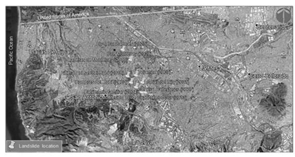
Figure 7: Record of landslides that occurred in sites with similar conditions to the study area.
Hazard assessment
The landslide hazard in the profiles of Figure 6 was evaluated based on spatial and temporal probabilities, using equation (3)
RESULTS
This section presents the results obtained in the case study when applying the procedure proposed in the Figure 5.
Landslide spatial probability assessment
Based on the results of the studies and available data, the geological-geotechnical models were elaborated to determine the susceptibility of the land to landslides in the selected profiles (Figure 8).
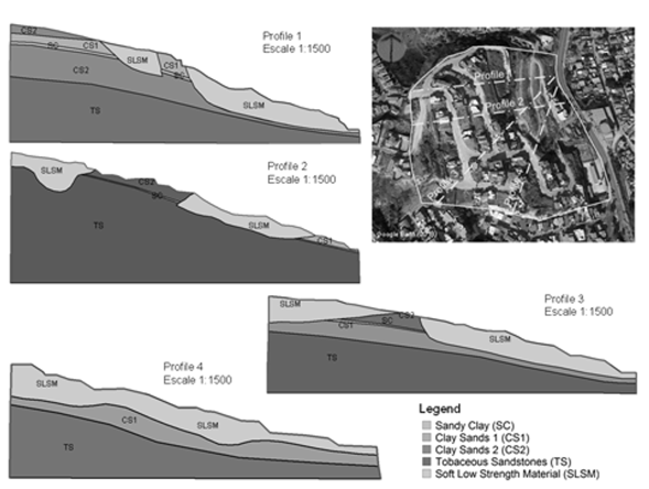
Figure 8: Geological-geotechnical models of the profiles used in slope stability analysis.
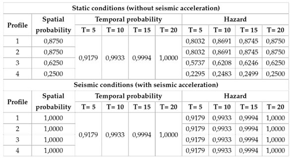
Stability analyzes were performed using methods based on limit equilibrium, enabling the identification of the potential landslide surfaces along with their corresponding factors of safety (Table 4). The effect of seismicity activity on instability was accounted for by integrating the analysis the seismic accelerations of the ground, as outlined in the complementary technical standards of the state of Baja California (NTC, 2017), as well as their amplification by site effect (Acosta-Chang et al., 2009). Also, in the static condition, a 50 % saturation of the land was considered to evaluate the influence of the small underground water flows detected in the study area.
Source: authors.
Table 4: Minimum factor of safety
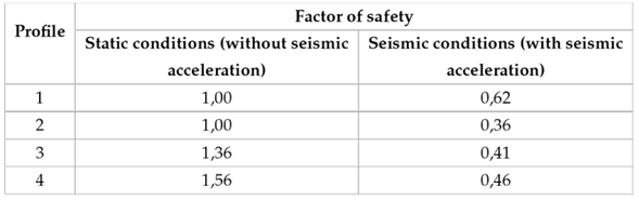
Figure 9 shows the potential slip surfaces obtained in the most unfavorable scenarios using different limit equilibrium methods (SLOPE/W, 2012). Likewise, Table 5 shows the spatial landslides probability obtained through slope stability analysis.
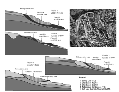
Figure 9: Areas of potential landslides and possible instabilities up and down slopes.
Source: authors.
Table 5: Landslides spatial probability in the study area.
Considering the pathologies and evidence of geotechnical instability existing in the study area and based on spatial probability values, landslide susceptibility was ordered into five classes: very low (0.00 - 0.20), low (0.20 - 0.40), moderate (0.40 - 0.60), high (0.60 - 0.80), and very high (0.80 - 1.00).
Landslide temporal probability estimation
The landslides temporal probability occurrence in the study area was estimated using equation (2), for return periods (T ) of 5, 10, 15, and 20 years, considering a mean recurrence interval (RI) of 2 years (Figure 10).
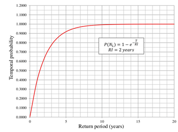
Figure 10: Landslides temporal probability in the study area.
We have assumed that pass events serve as indicators of potential future occurrences. Therefore, utilizing the graph presented in Figure 10, it becomes possible to project the behavior of landslides in the studied area over the next 20 years.
Landslide hazard assessment
From the spatial and temporal probabilities, the landslides hazard in the study area was assessed, using equation (3). Table 6 and Figure 11 show the results.
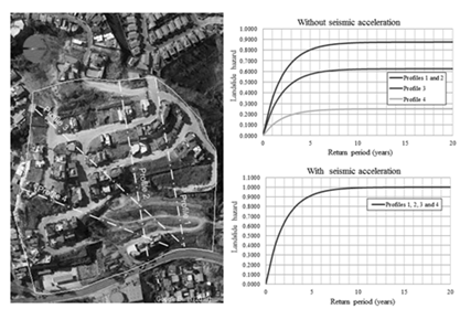
Figure 11: Landslide hazard for return periods of 5, 10, 15, and 20 years.
The landslide hazard was divided into five classes, based on susceptibility and the temporal probability of occurrence in the study area: very low (0.00 0.15), low (0.15 0.30), moderate (0.30 0.45), high (0.45 0.60), and very high (0.60 - 0.75).
Under static conditions (without ground acceleration), the landslide hazard in profiles 1, 2, and 3 for return periods of 5, 10, 15, and 20 years is greater than 0.50, thus falling in the high and very high categories (Figure 11). In a return period equal to the mean recurrence interval that characterizes the area where the neighborhood is located (T = RI = 2), the hazard in profiles 1 and 2 is 0.55 (high), in profile 3 it is 0.39 (moderate) and in profile 4 it is 0.15 (low). In seismic conditions, with ground accelerations close to 0.30g, the hazard is very high throughout the study area for any return period. In these cases, large landslides will surely occur.
Source: authors.
Table 6: Results of the quantitative assessment of the landslides hazard.
CONCLUSIONS
The quantitative assessment of the landslides hazard in the "Laderas de Monterrey” neighborhood was carried out based on existing information on the physical environment of the studied area, as well as on the records of landslides that occurred in sites with similar characteristics, using deterministic and probabilistic methods. The use of models based on the analysis of the slope stability allowed for an assessment of its susceptibility to landslides considering different scenarios. Moreover, it helped to demonstrate that the seismicity of the region, the topography, and the geotechnical properties of the soils are the factors with the greatest influence on the terrain instability. Particularly, the underground flows and the humidity produced by the infiltration of water through cracks and fractures in the studied area considerably reduce the strength of the materials and cause strain and displacement in the terrain. This deterioration process occurs in so-called soft, low-strength materials (SLSM) found in the areas of greatest instability and with the highest potential for landslides (Figure 9). On the other hand, the occurrence of landslides with an average recurrence interval of two years in a close environment confirms the high probability of occurrence of these phenomena in the studied area. Consequently, we find that for return periods of 5, 10, 15, and 20 years, the existing susceptibility and the temporal probability indicate a high hazard of occurrence of landslides in more tan 50 % of the study area under static conditions (without seismic acceleration); while in seismic conditions, with accelerations around 0.30g, the hazard is very high within the study area. The results obtained are an important step in analyzing and evaluating the risk that landslides represent for structures, infrastructures and people exposed to the impact of these phenomena. They are also a valuable tool for making informed decisions related to risk management and the establishment of regulations on land use.
Acknowledgements
ACKNOWLEDGMENTS
This article and the research that supports it is the result of the collaboration between the University of the International Californias (Mexico), the Geological and Mining Institute of Spain and the Francisco de Paula Santander Ocaña University (Colombia). The studies and work carried out here were possible thanks to the collaboration of the Neighbors Association of Laderas de Monterrey, Planning Metropolitan Institute of Tijuana, and the companies MUROTEC, AMAYA CURIEL Group, GEOCIM, and ITEICO Group.
REFERENCIAS
License
Copyright (c) 2023 Aldo Onel Oliva González, Romel Jesús Gallardo Amaya, Pedro Nel Angarita Uscátegui

This work is licensed under a Creative Commons Attribution-ShareAlike 4.0 International License.
Esta licencia permite a otros remezclar, adaptar y desarrollar su trabajo incluso con fines comerciales, siempre que le den crédito y concedan licencias para sus nuevas creaciones bajo los mismos términos. Esta licencia a menudo se compara con las licencias de software libre y de código abierto “copyleft”. Todos los trabajos nuevos basados en el tuyo tendrán la misma licencia, por lo que cualquier derivado también permitirá el uso comercial. Esta es la licencia utilizada por Wikipedia y se recomienda para materiales que se beneficiarían al incorporar contenido de Wikipedia y proyectos con licencias similares.