DOI:
https://doi.org/10.14483/2256201X.19250Publicado:
01-01-2023Número:
Vol. 26 Núm. 1 (2023): Enero-junioSección:
Artículos de investigación científica y tecnológicaVehículos aéreos no tripulados para el monitoreo del estado nutricional y fitosanitario de cultivos forestales
Unmanned Aerial Vehicles to Monitor the Nutritional and Phytosanitary Status of Forest Crops
Palabras clave:
Dron, plagas y enfermedades forestales, nutrición forestal, plantaciones forestales, monitoreo (es).Palabras clave:
Drone, pest and diseases, forest nutrition, pests, forestry plantations, monitoring (en).Descargas
Referencias
REFERENCIAS
Alvarado, A., & Raigosa, J. (2012). Nutrición y fertilización forestal en regiones tropicales. Agronomía Costarricense, 36(1), 113-115. https://www.scielo.sa.cr/scielo.php?script=sci_arttext&pid=S0377-94242012000100009
Anderson, K., & Gaston, K. J. (2013). Lightweight unmanned aerial vehicles will revolutionize spatial ecology. Frontiers in Ecology and the Environment, 11(3), 138-146. https://doi.org/10.1890/120150 DOI: https://doi.org/10.1890/120150
Arriola-Valverde., S, Ferencz-Appel, A., & Rimolo-Donadio, R. (2018). Fotogrametría terrestre con sistemas aéreos autónomos no tripulados. Investiga.Tec, 31, 3475. https://doi.org/10.18845/tm.v29i4.3040 DOI: https://doi.org/10.18845/tm.v29i4.3040
Avtar, R., & Watanabe, T. (Eds.). (2020). Unmanned aerial vehicle: Applications in agriculture and environment. Springer International Publishing. DOI: https://doi.org/10.1007/978-3-030-27157-2
Balasubramaniam, P., & Ananthi, V. P. (2016). Segmentation of nutrient deficiency in incomplete crop images using intuitionistic fuzzy C-means clustering algorithm. Nonlinear Dynamics, 83(1), 849-866. https://doi.org/10.1007/s11071-015-2372-y DOI: https://doi.org/10.1007/s11071-015-2372-y
Banu, T. P., Borlea, G. F., & Banu, C. (2016). The use of drones in forestry. Journal of Environmental Science and Engineering B, 5(11), 557-562. https://doi.org/10.17265/2162-5263/2016.11.007 DOI: https://doi.org/10.17265/2162-5263/2016.11.007
Barbedo, J. G. A. (2016). A review on the main challenges in automatic plant disease identification based on visible range images. Biosystems Engineering, 144, 52-60. https://doi.org/10.1016/j.biosystemseng.2016.01.017 DOI: https://doi.org/10.1016/j.biosystemseng.2016.01.017
Barbedo, J. G. A. (2019). A review on the use of unmanned aerial vehicles and imaging sensors for monitoring and assessing plant stresses. Drones, 3(2), 40. https://doi.org/10.3390/drones3020040 DOI: https://doi.org/10.3390/drones3020040
Berie, H. T., & Burud, I. (2018). Application of unmanned aerial vehicles in earth resources monitoring: focus on evaluating potentials for forest monitoring in Ethiopia. European Journal of Remote Sensing, 51(1), 326-335. https://doi.org/10.1080/22797254.2018.1432993 DOI: https://doi.org/10.1080/22797254.2018.1432993
Colomina, I., & Molina, P. (2014). Unmanned aerial systems for photogrammetry and remote sensing: A review. ISPRS Journal of Photogrammetry and Remote Sensing, 92, 79-97. https://doi.org/10.1016/j.isprsjprs.2014.02.013 DOI: https://doi.org/10.1016/j.isprsjprs.2014.02.013
Congalton, R. G., Gu, J., Yadav, K., Thenkabail, P., & Ozdogan, M. (2014). Global land cover mapping: A review and uncertainty analysis. Remote Sensing, 6(12), 12070-12093. https://doi.org/10.3390/rs61212070 DOI: https://doi.org/10.3390/rs61212070
Dang-Ngoc, H., & Nguyen-Trung, H. (2019, 17-19 de octubre). Aerial forest fire surveillance-evaluation of forest fire detection model using aerial videos [Conference presentation]. 2019 International Conference on Advanced Technologies for Communications (ATC), Hannoi, Vietnam. https://doi.org/10.1109/atc.2019.8924547 DOI: https://doi.org/10.1109/ATC.2019.8924547
Dash, J., Pont, D., Brownlie, R., Dunningham, A., Watt, M., & Pearse, G. (2016). Remote sensing for precision forestry. New Zealand Journal of Forestry Science, 60(4), 15-24.
de Lima Santos, I. C., dos Santos, A., Costa, J. G., Rosa, A. M., Zanuncio, A. J. V., Zanetti, R., Oumar, Z., & Zanuncio, J. C. (2021). Tectona grandis canopy cover predicted by remote sensing. Precision Agriculture, 22(3), 647-659. https://doi.org/10.1007/s11119-020-09748-w DOI: https://doi.org/10.1007/s11119-020-09748-w
Duarte, A., Acevedo-Muñoz, L., Gonçalves, C. I., Mota, L., Sarmento, A., Silva, M., Fabres, S., Borralho, N., & Valente, C. (2020). Detection of longhorned borer attack and assessment in eucalyptus plantations using UAV imagery. Remote Sensing, 12(19), 3153. https://doi.org/10.3390/rs12193153 DOI: https://doi.org/10.3390/rs12193153
Fernández-Moya, J., Alvarado, A., San Miguel-Ayanz, A., & Marchamalo-Sacristán, M. (2014). Forest nutrition and fertilization in teak (Tectona grandis Lf) plantations in Central America. New Zealand Journal of Forestry Science, 44, S6. https://doi.org/10.1186/1179-5395-44-s1-s6 DOI: https://doi.org/10.1186/1179-5395-44-S1-S6
Getzin, S., Nuske, R. S., & Wiegand, K. (2014). Using unmanned aerial vehicles (UAV) to quantify spatial gap patterns in forests. Remote Sensing, 6(8), 6988-7004. https://doi.org/10.3390/rs6086988 DOI: https://doi.org/10.3390/rs6086988
Jia, L., Chen, X., Zhang, F., Buerkert, A., & Römheld, V. (2004). Use of digital camera to assess nitrogen status of winter wheat in the northern China plain. Journal of Plant Nutrition, 27(3), 441-450. https://doi.org/10.1081/pln-120028872 DOI: https://doi.org/10.1081/PLN-120028872
Khan, A., Gupta, S., & Gupta, S. K. (2020). Multi-hazard disaster studies: Monitoring, detection, recovery, and management, based on emerging technologies and optimal techniques. International Journal of Disaster Risk Reduction, 47, 101642. https://doi.org/10.1016/j.ijdrr.2020.101642 DOI: https://doi.org/10.1016/j.ijdrr.2020.101642
Lee, S., Park, S., Baek, G., Kim, H., & Lee, C. (2019). Detection of damaged pine tree by the pine wilt disease using UAV Image. Korean Journal of Remote Sensing, 35(3), 359-373.
Lehmann, J. R. K., Nieberding, F., Prinz, T., & Knoth, C. (2015). Analysis of unmanned aerial system-based CIR images in forestry—A new perspective to monitor pest infestation levels. Forests, 6(3), 594-612. https://doi.org/10.3390/f6030594 DOI: https://doi.org/10.3390/f6030594
Lin, Q., Huang, H., Wang, J., Huang, K., & Liu, Y. (2019). Detection of pine shoot beetle (PSB) stress on pine forests at individual tree level using UAV-based hyperspectral imagery and lidar. Remote Sensing, 11(21), 2540. https://doi.org/10.3390/rs11212540 DOI: https://doi.org/10.3390/rs11212540
Megat Mohamed Nazir, M. N., Terhem, R., Norhisham, A. R., Mohd Razali, S., & Meder, R. (2021). Early monitoring of health status of plantation-grown Eucalyptus pellita at large spatial scale via visible spectrum imaging of canopy foliage using unmanned aerial vehicles. Forests, 12(10), 1393. https://doi.org/10.3390/f12101393 DOI: https://doi.org/10.3390/f12101393
Méndez, A., Vélez, J., Scaramuzza, F., & Villaroel, D. (2015). Los drones como herramienta para el monitoreo de cultivos. Revista de la Bolsa de Comercio de Rosario, (1524), 6-10. https://www.bcr.com.ar/sites/default/files/drones.pdf
Michez, A., Piégay, H., Lisein, J., Claessens, H., & Lejeune, P. (2016). Classification of riparian forest species and health condition using multi-temporal and hyperspatial imagery from unmanned aerial system. Environmental Monitoring and Assessment, 188(3), 146. https://doi.org/10.1007/s10661-015-4996-2 DOI: https://doi.org/10.1007/s10661-015-4996-2
Miraki, M., Sohrabi, H., Fatehi, P., & Kneubuehler, M. (2021). Detection of mistletoe infected trees using UAV high spatial resolution images. Journal of Plant Diseases and Protection, 128, 1679-1689. https://doi.org/10.1007/s41348-021-00502-6 DOI: https://doi.org/10.1007/s41348-021-00502-6
Nauš, J., Prokopová, J., Řebíček, J., & Špundová, M. (2010). SPAD chlorophyll meter reading can be pronouncedly affected by chloroplast movement. Photosynthesis Research, 105(3), 265-271. https://doi.org/10.1007/s11120-010-9587-z DOI: https://doi.org/10.1007/s11120-010-9587-z
Nex, F., y Remondino, F. (2014). UAV for 3D mapping applications: A review. Applied Geomatics, 6, 1-15. https://doi.org/10.1007/s12518-013-0120-x DOI: https://doi.org/10.1007/s12518-013-0120-x
Ortiz-Malavassi, E., Tapia-Arenas, A., Guevara-Bonilla, M., & Hernández-Cole, J. (2020). Viabilidad del uso de los VANTS en el monitoreo de plantaciones forestales. Boletín técnico. https://drive.google.com/drive/u/0/folders/104yhSyE2rMG4hTPs__52V_kvxCZaOZwh
Otsu, K., Pla, M., Vayreda, J., & Brotons, L. (2018). Calibrating the severity of forest defoliation by pine processionary moth with Landsat and UAV imagery. Sensors, 18(10), 3278. https://doi.org/10.3390/s18103278 DOI: https://doi.org/10.3390/s18103278
Pádua, L., Vanko, J., Hruška, J., Adão, T., Sousa, J. J., Peres, E., & Morais, R. (2017). UAS, sensors, and data processing in agroforestry: A review towards practical applications. International Journal of Remote Sensing, 38(8-10), 2349-2391. https://doi.org/10.1080/01431161.2017.1297548 DOI: https://doi.org/10.1080/01431161.2017.1297548
Pedrali, L. D., Borges Junior, N., Pereira, R. S., Tramontina, J., Alba, E., & Marchesan, J. (2019). Multispectral remote sensing for determining dry severity levels of pointers in Eucalyptus spp. Scientia Forestalis, 47(122), 224-234. https://doi.org/10.18671/scifor.v47n122.05 DOI: https://doi.org/10.18671/scifor.v47n122.05
Prado Osco, L., Marques Ramos, A. P., Roberto Pereira, D., Akemi Saito Moriya, É, Nobuhiro Imai, N., Takashi Matsubara, E., Estrabis, N., de Souza, M., Marcato Junior, J., & Gonçalves, W. N. (2019). Predicting canopy nitrogen content in citrus-trees using random forest algorithm associated to spectral vegetation indices from UAV-imagery. Remote Sensing, 11(24), 2925. https://doi.org/10.3390/rs11242925 DOI: https://doi.org/10.3390/rs11242925
Qin, J., Wang, B., Wu, Y., Lu, Q., & Zhu, H. (2021). Identifying Pine Wood Nematode Disease Using UAV Images and Deep Learning Algorithms. Remote Sensing, 13(2), 162. https://doi.org/10.3390/rs13020162 DOI: https://doi.org/10.3390/rs13020162
Quintana, R. (2014). Técnicas avanzadas de análisis para los cultivos en tiempo real. En IICA y PROCISUR (Eds.), Manual de agricultura de precisión (pp. 58-70). IICA.
Ramírez-Mesén, C. M. (2019). Uso de un vehículo aéreo no tripulado como alternativa para evaluar el estado nutricional de una plantación de Gmelina arborea Roxb, San Carlos, Costa Rica. https://repositoriotec.tec.ac.cr/bitstream/handle/2238/11154/uso_vehiculo_aereo_no_tripulado.pdf?sequence=1&isAllowed=y
Richards, J. A., & Richards, J. A. (1999). Remote sensing digital image analysis. Springer. DOI: https://doi.org/10.1007/978-3-662-03978-6
Sims, N. C., Culvenor, D., Newnham, G., Coops, N. C., & Hopmans, P. (2013). Towards the operational use of satellite hyperspectral image data for mapping nutrient status and fertilizer requirements in Australian plantation forests. IEEE Journal of Selected Topics in Applied Earth Observations and Remote Sensing, 6(2), 320-328. https://doi.org/10.1109/jstars.2013.2251610 DOI: https://doi.org/10.1109/JSTARS.2013.2251610
Smigaj, M., Gaulton, R., Barr, S. L., & Suárez, J. C. (2015). UAV-borne thermal imaging for forest health monitoring: detection of disease induced canopy temperature increase. International Archives of the Photogrammetry, Remote Sensing & Spatial Information Sciences, XL-3/W3, 349-354. https://doi.org/10.5194/isprsarchives-xl-3-w3-349-2015 DOI: https://doi.org/10.5194/isprsarchives-XL-3-W3-349-2015
Tahir, M. N., Naqvi, S. Z. A., Lan, Y., Zhang, Y., Wang, Y., Afzal, M., Cheema, M. J. M., & Amir, S. (2018). Real time estimation of chlorophyll content based on vegetation indices derived from multispectral UAV in the kinnow orchard. International Journal of Precision Agricultural Aviation, 1(1), 24-31. http://dx.doi.org/10.33440/j.ijpaa.20180101.0001 DOI: https://doi.org/10.33440/j.ijpaa.20180101.0001
Tang, L., & Shao, G. (2015). Drone remote sensing for forestry research and practices. Journal of Forestry Research, 26(4), 791-797. https://doi.org/10.1007/s11676-015-0088-y DOI: https://doi.org/10.1007/s11676-015-0088-y
Torresan, C., Berton, A., Carotenuto, F., Di Gennaro, S. F., Gioli, B., Matese, A., Miglietta, F., Vagnoli, C., Zaldei, A., & Wallace, L. (2017). Forestry applications of UAVs in Europe: A review. International Journal of Remote Sensing, 38(8-10), 2427-2447. https://doi.org/10.1080/01431161.2016.1252477 DOI: https://doi.org/10.1080/01431161.2016.1252477
Tsouros, D. C., Bibi, S., & Sarigiannidis, P. G. (2019). A review on UAV-based applications for precision agriculture. Information, 10(11), 349. https://doi.org/10.3390/info10110349 DOI: https://doi.org/10.3390/info10110349
Watt, M. S., Pearse, G. D., Dash, J. P., Melia, N., & Leonardo, E. M. C. (2019). Application of remote sensing technologies to identify impacts of nutritional deficiencies on forests. ISPRS Journal of Photogrammetry and Remote Sensing, 149, 226-241. https://doi.org/10.1016/j.isprsjprs.2019.01.009 DOI: https://doi.org/10.1016/j.isprsjprs.2019.01.009
Wu, B., Liang, A., Zhang, H., Zhu, T., Zou, Z., Yang, D., Tang, W., Li, J., & Su, J. (2021). Application of conventional UAV-based high-throughput object detection to the early diagnosis of pine wilt disease by deep learning. Forest Ecology and Management, 486, 118986. https://doi.org/10.1016/j.foreco.2021.118986 DOI: https://doi.org/10.1016/j.foreco.2021.118986
Yu, R., Luo, Y., Zhou, Q., Zhang, X., Wu, D., & Ren, L. (2021a). Early detection of pine wilt disease using deep learning algorithms and UAV-based multispectral imagery. Forest Ecology and Management, 497, 119493. https://doi.org/10.1016/j.foreco.2021.119493 DOI: https://doi.org/10.1016/j.foreco.2021.119493
Yu, R., Luo, Y., Zhou, Q., Zhang, X., Wu, D., & Ren, L. (2021b). A machine learning algorithm to detect pine wilt disease using UAV-based hyperspectral imagery and LiDAR data at the tree level. International Journal of Applied Earth Observation and Geoinformation, 101, 102363. https://doi.org/10.1016/j.jag.2021.102363 DOI: https://doi.org/10.1016/j.jag.2021.102363
Yu, R., Ren, L., & Luo, Y. (2021c). Early detection of pine wilt disease in Pinus tabuliformis in North China using a field portable spectrometer and UAV-based hyperspectral imagery. Forest Ecosystems, 8(1), 1-19. https://doi.org/10.1186/s40663-021-00328-6 DOI: https://doi.org/10.1186/s40663-021-00328-6
Yu, L., Zhan, Z., Ren, L., Zong, S., Luo, Y., & Huang, H. (2020). Evaluating the potential of WorldView-3 data to classify different shoot damage ratios of Pinus yunnanensis. Forests, 11(4), 417. https://doi.org/10.3390/f11040417 DOI: https://doi.org/10.3390/f11040417
Yuan, Y., & Hu, X. (2016). Random forest and objected-based classification for forest pest extraction from UAV aerial imagery. The International Archives of Photogrammetry, Remote Sensing and Spatial Information Sciences, 41, 1093. https://doi.org/10.5194/isprsarchives-xli-b1-1093-2016 DOI: https://doi.org/10.5194/isprsarchives-XLI-B1-1093-2016
Zhang, N., Zhang, X., Yang, G., Zhu, C., Huo, L., & Feng, H. (2018). Assessment of defoliation during the Dendrolimus tabulaeformis Tsai et Liu disaster outbreak using UAV-based hyperspectral images. Remote Sensing of Environment, 217, 323-339. https://doi.org/10.1016/j.rse.2018.08.024 DOI: https://doi.org/10.1016/j.rse.2018.08.024
Cómo citar
APA
ACM
ACS
ABNT
Chicago
Harvard
IEEE
MLA
Turabian
Vancouver
Descargar cita
Recibido: 1 de abril de 2022; Aceptado: 27 de septiembre de 2022
Resumen
El uso de vehículos aéreos no tripulados (VANTs) en el monitoreo de plantaciones forestales permite obtener información precisa sobre distintos atributos de los árboles. Este trabajo presenta una revisión crítica del uso potencial de los VANTs para el monitoreo del estado nutricional y fitosanitario de plantaciones forestales. Se realizó una búsqueda bibliográfica en las plataformas Google Scholar, Scopus y Science Direct, utilizando palabras claves como estrés, nutrición y forestería. Se encontraron estudios principalmente en el género Pinus y en el continente asiático, que utilizan drones de ala fija y rotatoria para el monitoreo de plagas y enfermedades. Las experiencias en el monitoreo de deficiencias nutricionales son pocas. El uso futuro de VANTs para el monitoreo de estreses en cultivos forestales parece ir dirigido a la automatización en la toma de datos y a combinación de estos con algoritmos de inteligencia artificial.
Palabras clave:
dron, plagas y enfermedades forestales, nutrición forestal, plantaciones forestales, monitoreo..Abstract
The use of unmanned aerial vehicles (UAVs) to monitor forest plantations allows obtaining precise information on different tree attributes. This paper presents a critical review of the potential use of UAVs for monitoring the nutritional and phytosanitary status of forest plantations. A bibliographic search was carried out on the Google Scholar, Scopus, and Science Direct platforms, using keywords such as stress, nutrition, and forestry. Studies were found mainly on the genus Pinus and the Asian continent which use fixed and rotary wing drones to monitor pests and diseases. Experiences in monitoring nutritional deficiencies are few. The future use of UAVs for stress monitoring in forest crops seems to be aimed at automating data collection and combining these with artificial intelligence algorithms.
Keywords:
drone, pest and diseases, forest nutrition, pests, forestry plantations, monitoring..INTRODUCCIÓN
La innovación tecnológica permite el uso de nuevas herramientas para el manejo de los recursos naturales. Por mucho tiempo, el uso de imágenes procedentes de sensores remotos ha sido una de las principales herramientas tecnológicas para el monitoreo de variables ambientales.
Con la aplicación del concepto de agricultura de precisión, y con el desarrollo de la cuarta revolución industrial (Industria 4.0), se han introducido tecnologías que combinan vehículos aéreos no tripulados (VANTs) con sensores remotos, cámaras de alta resolución, sistemas de posicionamiento global (GPS) para la recolección de datos de sitio y sistemas de información geográfica para su procesamiento (Tsouros et al., 2019).
El uso de VANTs con cámaras incorporadas tiene gran potencial para el manejo de cultivos, debido a que estos dispositivos ofrecen la posibilidad de disponer imágenes de alta resolución (Dash et al., 2016) y hacer mediciones precisas y no destructivas de distintos atributos de los árboles (Berie & Burud, 2018). Este potencial también se debe a la poca utilización de materiales, la alta intensidad de recolección de datos (Tang & Shao, 2015) y bajo costo (Colomina & Molina, 2014).
Recientemente, el uso de VANTs ha ganado popularidad y ha generado un creciente interés, dados los diferentes tamaños, formas y capacidades de operación de estos dispositivos, con un amplio espectro de aplicaciones civiles y de investigación (Banu et al., 2016; Tang & Shao, 2015).
A nivel mundial se han realizado diversas investigaciones sobre la aplicación de drones en el campo forestal (Torresan et al. 2016), en la estimación del diámetro de los árboles (de Lima et al., 2021), en la evaluación y detección de incendios forestales (Dang-Ngoc & Nguyen-Trung, 2019), en la cuantificación de aperturas del dosel (Getzin et al., 2014) y en labores de monitoreo forestal (Khan et al., 2020). Otras actividades como el monitoreo de problemas nutricionales o fitosanitarios podrían tener un gran potencial en un futuro cercano.
Es por tal motivo que este artículo presenta los resultados de una revisión bibliográfica acerca de las características básicas de los vehículos aéreos no tripulados, así como de su uso potencial para el monitoreo y evaluación del estado nutricional y fitosanitario de plantaciones forestales.
MATERIALES Y MÉTODOS
La búsqueda de artículos relevantes comprendió un período de 10 años (2011-2021) y se realizó utilizando Google Scholar y los repositorios Scopus y Science Direct. La búsqueda se realizó en noviembre de 2021, utilizando tres grupos de palabras clave: los términos "drone", "UAV" y "UAS", en combinación con los términos "estrés", "enfermedad", "nutrición" y "plaga", así como con los términos “forestería” y “plantaciones forestales”. La búsqueda no se vio limitada por artículos con acceso restringido.
RESULTADOS
Aeronaves piloteadas a distancia como plataforma de captura de información
Los VANTs (o drones, como se les conoce popularmente) son plataformas que operan de manera autónoma o mediante pilotaje remoto. Generalmente están compuestos por un cuerpo principal, motores y propelas, un control remoto, batería o baterías de carga y hélices o alas para poder realizar un vuelo.
Tang y Shao (2015) clasifican a los VANTs en dos categorías de acuerdo con las técnicas de despegue y aterrizaje: (i) drones de ala fija (aviones), los cuales tienen características de despegue y aterrizaje horizontal; y (ii) aeronaves de rotor o de ala giratoria, que realizan las labores de despegue y aterrizaje de forma vertical. Estos últimos pueden poseer cuatro, seis o más hélices. Otros autores clasifican a los VANTs de acuerdo con su peso y rango o a su suministro de poder (Banu et al., 2016).
Los VANTs presentan numerosas ventajas. Por ejemplo, Banu et al. (2016) identifican a los drones como plataformas seguras, ligeras, flexibles y automatizadas, capaces de obtener datos de imágenes para muchas aplicaciones. Adicionalmente, son plataformas de bajo costo y presentan una alta eficiencia (Nex & Remondino, 2014).
Entre las principales limitantes de este tipo de tecnología se encuentran: (i) las restricciones de operación como la altura de vuelo y la distancia máximas permitidas según las regulaciones de cada país, (ii) el alto valor económico de algunos modelos, (iii) que algunos modelos recientes no permiten la opción de realizar vuelos autónomos, (iv) que la mayor cantidad de modelos no toleran la precipitación y (v) la dificultad para reconstruir o procesar imágenes de áreas muy homogéneas (Pádua et al., 2017). Adicionalmente, muchos países exigen una licencia de piloto o un nivel de capacitación alto (Méndez et al., 2015), y existen limitaciones en cuanto al equipo de cómputo requerido para el procesamiento adecuado de las imágenes capturadas (Valverde et al., 2018).
Cámaras y sensores que se pueden cargar
Richards (1999) menciona que, para la adquisición de datos, se destacan dos grandes grupos de sensores: (i) los pasivos, que incluyen cámaras RGB, cámaras multiespectrales, hiperespectrales o térmicas; y (ii) los activos, como los LiDAR, y la radiodetección.
Los sensores de luz visible (RGB) permiten captar imágenes perceptibles por el ojo humano y, utilizados en VANTs, son capaces de capturar imágenes de alta resolución espacial (Pádua et al., 2017).
Existen sensores que permiten captar información del espectro electromagnético más allá del espectro visible, e.g., rojo extremo (red edge) e infrarrojo. Este tipo de sensores, denominados multiespectrales, son de gran utilidad para el diagnóstico y monitoreo de la nutrición, así como de la presencia de plagas y enfermedades. Muy similares a los anteriores, están los sensores hiperespectrales, con una gran cantidad de bandas y sensibles y capaces de captar longitudes de onda muy específicas dentro del espectro electromagnético (Pádua et al., 2017).
Finalmente, dentro del grupo de sensores pasivos se encuentran los sensores termales, que permiten captar información térmica importante para determinar los estados hídricos de cultivos o plantaciones forestales; o los sensores químicos, que permiten conocer la existencia de componentes químicos peligrosos en el aire (Avtar & Watanabe, 2020).
Entre los sensores de tipo activo se encuentran el LiDAR y el sensor Radar. El primero utiliza la luz en forma de láser para medir los rangos o distancias variables desde el sensor hasta algún objeto, permitiendo generar información en tres dimensiones; mientras que el segundo puede captar información de obstáculos y podría tener aplicaciones en ejercicios de búsqueda y salvamento (Avtar & Watanabe, 2020).
Detección y cuantificación del estrés de las plantas utilizando VANTs
Diagnósticos nutricionales
El manejo de la fertilidad del suelo se define como el manejo de los nutrientes del mismo. Esta actividad se considera fundamental en las primeras etapas de desarrollo de una plantación, ya que condicionan su productividad (Fernández-Moya et al., 2014). Para el diagnóstico de la nutrición, tradicionalmente se han utilizado las técnicas de análisis químico del suelo y el análisis químico foliar (Alvarado & Raigosa, 2012), métodos conocidos y ampliamente utilizados en el sector forestal.
Adicionalmente, existen algunas alternativas indirectas disponibles para algunos nutrientes, como es el caso del medidor manual de clorofila (soil-plant analysis development, SPAD) para las predicciones de nitrógeno (Balasubramaniam & Ananthi, 2016), pero este es un proceso que requiere mucho tiempo (Jia et al., 2004), y sus estimaciones no siempre son precisas (Nauš et al., 2010).
Con el avance de la tecnología, los sensores remotos se han convertido en una herramienta útil para realizar diagnósticos nutricionales a nivel de paisaje (Watt et al., 2019). Una gran parte de los estudios sobre deficiencias nutricionales que se encuentran en la literatura utilizan imágenes hiperespectrales capturadas por satélites (Sims et al., 2013). Aunque algunos satélites lanzados recientemente pueden ofrecer altas resoluciones espaciales (Congalton et al., 2014), estas todavía son demasiado bajas para analizar árboles individuales, lo que significa que, en muchos casos, la deficiencia solo puede detectarse cuando ya está muy extendida. Los VANTs, por otro lado, pueden ofrecer resoluciones espaciales de menos de cinco centímetros sin los altos costos que conlleva la adquisición de imágenes satelitales.
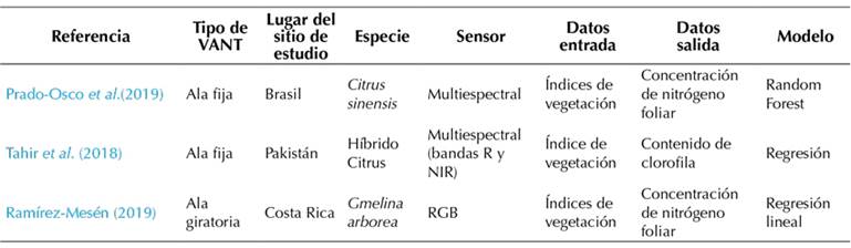
A pesar del potencial que pueden tener los VANTs en esta labor, solo existen publicaciones científicas y una tesis sobre este tema (Tabla 1). Los artículos científicos de Prado-Osco et al. (2019) y Tahir et al. (2018) trabajaron con árboles frutales, mientras que la tesis de Ramírez-Mesén (2019) se realizó con la especie forestal Gmelina arborea.
RGB: Cámara con bandas rojo, verde y azul, NIR: infrarrojo cercano.
Tabla 1: Referencias encontradas que tratan sobre deficiencias nutricionales en especies o plantaciones forestales
Plagas y enfermedades
Tradicionalmente, el monitoreo de plagas y enfermedades se realiza directamente en campo, evaluando visualmente la incidencia y severidad de la plaga o enfermedad. Sin embargo, la calidad de esta operación depende de la experiencia de la persona evaluadora, lo que podría inducir a errores. Por lo tanto, las herramientas basadas en imágenes pueden desempeñar un papel importante en la detección y el reconocimiento de plagas en los árboles cuando la evaluación humana no es adecuada, no es confiable o no está disponible, especialmente por la gran área que pueden cubrir los VANTs (Barbedo, 2019).
A diferencia del monitoreo y diagnóstico de la nutrición, en el campo forestal sí existen experiencias que utilizan VANTs para el monitoreo de plagas y enfermedades (Tabla 2). Un 80 % de los trabajos encontrados tienen una antigüedad de tres años. Además, un 73 % de los estudios encontrados fueron realizados con drones de ala giratoria (Lehmann et al., 2019; Miraki et al., 2021; Qin et al., 2021) y un 47 % fueron realizados en China. Cabe destacar que no se encontraron artículos con especies tropicales o realizados en regiones como Norteamérica o el continente africano.
Tabla 2: Referencias encontradas que tratan sobre problemas fitosanitarios en especies o plantaciones forestales
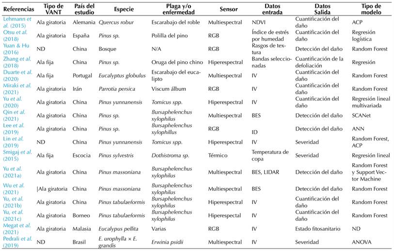
Las especies del género Pinus fueron predominantes en los estudios realizados, que se basaron en detección del daño producido o en una cuantificación del mismo (Yu et al., 2021b, 2021c). El uso de herramientas de aprendizaje automático ha sido frecuente en la detección y cuantificación de enfermedades. Las cámaras multiespectrales y RGB han sido los sensores favoritos para adquirir información, debido a su precio y fácil adquisición.
Tabla 2. Referencias encontradas que tratan sobre problemas fitosanitarios en especies o plantaciones forestales
RGB: cámara con bandas rojo, verde y azul; ACP: análisis de componentes principales; NDVI: Índice de vegetación de diferencia normalizada; IV: índices de vegetación; ID: imágenes de dron; ND: no data; ANN: red neuronal artificial; BES: bandas espectrales seleccionadas.
DISCUSIÓN
Entre los diferentes actores del sector forestal existe una percepción cada vez mayor de que los VANTs pueden ser herramientas útiles para el monitoreo y recopilación de información de plantaciones forestales. Ortiz et al. (2020) encontraron que al menos un 50 % de las necesidades de datos o información de las empresas de reforestación podría solventarse utilizando drones.
Sin embargo, el uso de esta tecnología para la evaluación nutricional en plantaciones forestales es incipiente. Para el diagnóstico y monitoreo de la nutrición en plantaciones forestales, tradicionalmente se han utilizado las técnicas de análisis químico de suelo y el análisis químico foliar (Alvarado, 2012; Watt et al., 2019), las cuales presentan desventajas como la alta demanda de tiempo y recursos (Quintana, 2014; Watt et al., 2019).
A pesar de que los VANTs se han utilizado para predecir cambios en el estrés fisiológico dentro de las plantaciones (Dash et al., 2016), a la fecha se han realizado pocas investigaciones de este tipo para monitorear las deficiencias nutricionales. Entre las limitantes para su utilización se encuentran el alto costo inicial del equipo, la poca duración de la batería, la capacidad de carga limitada y la necesidad de equipo y programas de cómputo especializados para el procesamiento y análisis de las imágenes.
A pesar de las limitaciones expuestas, las plantaciones forestales de una sola especie son las candidatas más probables para la aplicación a gran escala de los VANTs en la detección de deficiencias nutricionales. En este contexto, los drones con cámaras RGB o multiespectrales podrían utilizarse como complemento a los métodos tradicionales, así como en una fase de monitoreo inicial.
Entre las futuras aplicaciones de esta tecnología deben figurar métodos que puedan caracterizar los determinantes fisiológicos clave de la respuesta de los bosques a los fertilizantes. El índice de área foliar y la concentración de algunos elementos (i.e., N) son muy prometedores para diagnosticar y monitorear las deficiencias de nutrientes en rodales naturales o de plantaciones de especies individuales que se gestionan activamente (Watt et al., 2019). Adicionalmente, se podrían tomar decisiones sobre la aplicación de fertilizantes dentro de plantaciones forestales o para predecir con precisión las características de los árboles y las respuestas de tratamiento dentro de los ensayos de fertilizantes (Watt et al., 2019).
De acuerdo con lo analizado en este trabajo, existe una mayor cantidad de casos y mayor experiencia en el uso de VANTs para el monitoreo de plagas y enfermedades en cultivos forestales. Los VANTs de tamaño medio y las cámaras multiespectrales son las más utilizadas para este tipo de labores. Entre sus principales ventajas se encuentran su bajo costo, fácil maniobrabilidad en el aire y su facilidad de despegue y aterrizaje. Sin embargo, es importante considerar que, aunque este tipo de VANTs son fáciles de pilotear, la curva de aprendizaje puede ser pronunciada y se necesita de amplia experiencia. Adicionalmente, estos dispositivos tienen la desventaja de poseer una capacidad de carga limitada. Esto limita no solo los sensores que se pueden desplegar, sino también el tiempo de vuelo y, como consecuencia, la cobertura del área (Anderson & Gaston, 2013).
A diferencia del monitoreo nutricional, el monitoreo de plagas con este tipo de tecnología puede ser económicamente más viable, pues permitiría cubrir grandes extensiones en menor tiempo, hacer revisiones periódicas y monitorear áreas de difícil acceso. A pesar de que Lehmann et al. (2019) mencionan que la metodología utilizada en su estudio tuvo un fuerte impacto económico positivo, con una reducción de tiempo y dinero del 50 % en el trabajo de detección de plagas, la mayoría de los artículos analizados para este trabajo no presentan ni hacen un análisis de los costos de operación, así como del costo del procesamiento y análisis de las imágenes obtenidas.
Existen factores, como la iluminación, el ángulo de la cámara y las sombras de las copas de los árboles, que pueden tener un impacto significativo en la detección de plagas (Lehmann et al., 2015; Otsu et al., 2018). Barbedo (2016) menciona que los siguientes factores influyen en la identificación automática de enfermedades de las plantas:
-
El fondo de la imagen
-
Las condiciones de captura de imágenes
-
Las variaciones de los síntomas
-
Otros trastornos y tensiones
Un efecto en bosques y huertos es la defoliación de árboles, una señal que se ha explorado en algunos experimentos (Lehmann et al., 2015; Zhang et al., 2018). Además, los insectos pueden alterar los procesos fisiológicos y la fotosíntesis, provocando un impacto en la altura de la planta, efecto que puede detectarse mediante la fotogrametría.
El uso de VANTs para el monitoreo de se ha dado principalmente a nivel experimental y enfocado en regiones de Europa y Asia. A pesar de lo alentadores que han sido los resultados experimentales, la adopción práctica del uso de VANTs para el monitoreo de deficiencias nutricionales y/o problemas fitosanitarios ha sido lenta, independientemente del tipo de sensor o el método de implementación (Barbedo, 2019).
Una posible explicación es que existen muchos factores capaces de alterar el estado fisiológico y morfológico característico de los árboles en condiciones de campo, por lo que obtener respuestas inequívocas basadas únicamente en la información contenida en las imágenes se vuelve inviable con la tecnología actual (Barbedo, 2019). Otra posible razón es que no existen programas de capacitación formales para el uso de esta tecnología, y que el precio de esta no es el mismo en todas las regiones del mundo. En regiones como África o América Latina, el costo de adquisición de esta tecnología puede ser superior al de regiones como Asia, Europa o Norteamérica.
CONCLUSIONES
A pesar del uso de imágenes satelitales y de la experiencia en el monitoreo de cultivos agrícolas, el uso de sensores añadidos a los VANTs para el monitoreo y diagnóstico de deficiencias nutricionales en bosques o plantaciones forestales es casi nulo. Sin embargo, se prevé que en los próximos años aumente el número de investigaciones en este campo.
Por otra parte, existen experiencias en el uso de VANTs para la detección y cuantificación de daños en plagas y enfermedades forestales. La combinación de cámaras multiespectrales con algoritmos de aprendizaje automático permite una adecuada detección del daño y un monitoreo a mayor escala que los métodos tradicionales.
El futuro uso de esta tecnología para el monitoreo de estreses en cultivos forestales parece ir dirigido al uso de índices de vegetación, a la automatización en la toma de datos y a la combinación de estos con algoritmos de inteligencia artificial.
El uso práctico de esta tecnología dependerá del grado de éxito de los ensayos realizados, del nivel de costo del equipo y su operación, y de procesos de capacitación que permitan a técnicos y profesionales del sector forestal conocer, analizar y dar recomendaciones a partir de las imágenes capturadas.
Acknowledgements
AGRADECIMIENTOS
Los autores agradecen a la Vicerrectoría de Investigación y Extensión del Instituto Tecnológico de Costa Rica por financiar este proyecto.
REFERENCIAS


Licencia
Derechos de autor 2023 Colombia forestal

Esta obra está bajo una licencia internacional Creative Commons Atribución-CompartirIgual 4.0.
Colombia Forestal conserva los derechos patrimoniales (copyright) de las obras publicadas, y favorece y permite la reutilización de las mismas bajo la licencia Creative Commons Atribución-CompartirIgual 4.0 Internacional por lo cual se pueden copiar, usar, difundir, transmitir y exponer públicamente, siempre que:
Se reconozcan los créditos de la obra de la manera especificada por el autor o el licenciante (pero no de una manera que sugiera que tiene su apoyo o que apoyan el uso que hace de su obra).