DOI:
https://doi.org/10.14483/2256201X.20111Publicado:
01-01-2024Número:
Vol. 27 Núm. 1 (2024): Enero-junioSección:
Artículos de investigación científica y tecnológicaAnálisis espacial y temporal de incendios forestales en el Ecuador utilizando datos de sensores remotos
Spatial and Temporal Analysis of Wildfires in Ecuador Using Remote Sensing Data
Palabras clave:
Burning, forest, MODIS, vegetation (en).Palabras clave:
Quemas, bosque, MODIS, vegetación (es).Descargas
Referencias
Alvear, J. G. (2008, abril 19-22). Gestión en la protección contra los incendios forestales en América del Sur [Presentación en conferencia]. Segundo simposio internacional sobre políticas, planificación y economía de los programas de protección contra incendios forestales: una visión global, Córdoba, España.
Armenteras, D., González, T. M., Vargas, O., Meza Elizalde, M. C., & Oliveras, I. (2020). Incendios en ecosistemas del norte de Suramérica: avances en la ecología del fuego tropical en Colombia, Ecuador y Perú. Caldasia, 42(1), 1-16. https://doi.org/10.15446/caldasia.v42n1.77353 DOI: https://doi.org/10.15446/caldasia.v42n1.77353
Armenteras, D., Retana-Alumbreros, J., Molowny-Horas, R., Roman-Cuesta, R. M., Gonzalez-Alonso, F., & Morales-Rivas, M. (2011). Characterising fire spatial pattern interactions with climate and vegetation in Colombia. Agricultural and Forest Meteorology, 151(3), 279-289. https://doi.org/10.1016/j.agrformet.2010.11.002 DOI: https://doi.org/10.1016/j.agrformet.2010.11.002
Armenteras, D., & Retana, J. (2012). Dynamics, patterns and causes of fires in Northwestern Amazonia. PLOS One, 7(4), e35288. https://doi.org/10.1371/JOURNAL.PONE.0035288 DOI: https://doi.org/10.1371/journal.pone.0035288
Barbosa, P. M., Stroppiana, D., Grégoire, J. M., & Pereira, J. M. C. (1999). An assessment of vegetation fire in Africa (1981-1991): Burned areas, burned biomass, and atmospheric emissions. Global Biogeochemical Cycles, 13(4), 933-950. https://doi.org/10.1029/1999GB900042 DOI: https://doi.org/10.1029/1999GB900042
Brando, P. M., Coe, M. T., DeFries, R., & Azevedo, A. A. (2013). Ecology, economy and management of an agroindustrial frontier landscape in the southeast Amazon. Philosophical Transactions of the Royal Society B: Biological Sciences, 368(1619), 0152. https://doi.org/10.1098/RSTB.2012.0152 DOI: https://doi.org/10.1098/rstb.2012.0152
Cano-Crespo, A., Oliveira, P. J. C., Boit, A., Cardoso, M., & Thonicke, K. (2015). Forest edge burning in the Brazilian Amazon promoted by escaping fires from managed pastures. Journal of Geophysical Research: Biogeosciences, 120(10), 2095-2107. https://doi.org/10.1002/2015JG002914 DOI: https://doi.org/10.1002/2015JG002914
Carrión-Paladines, V., Belén Hinojosa, M., Jiménez Álvarez, L., Reyes-Bueno, F., Correa Quezada, L., & García-Ruiz, R. (2022). Effects of the severity of wildfires on some physical-chemical soil properties in a humid montane scrublands ecosystem in Southern Ecuador. Fire, 5(3), 66. https://doi.org/10.3390/FIRE5030066 DOI: https://doi.org/10.3390/fire5030066
Carvalho, N. S., Anderson, L. O., Nunes, C. A., Pessôa, A. C. M., Silva Junior, C. H. L., Reis, J. B. C., Shimabukuro, Y. E., Berenguer, E., Barlow, J., & Aragão, L. E. O. C. (2021). Spatio-temporal variation in dry season determines the Amazonian fire calendar. Environmental Research Letters, 16(12), 125009. https://doi.org/10.1088/1748-9326/AC3AA3 DOI: https://doi.org/10.1088/1748-9326/ac3aa3
Castillo, M., Pedernera, P., & Pena, E. (2003). Incendios forestales y medio ambiente: una síntesis global. Revista Ambiente y Desarrollo, 9(3), 44-53.
Catarino, S., Romeiras, M. M., Figueira, R., Aubard, V., Silva, J. M. N., & Pereira, J. M. C. (2020). Spatial and temporal trends of burnt area in Angola: Implications for natural vegetation and protected area management. Diversity, 12(8), 307. https://doi.org/10.3390/D12080307 DOI: https://doi.org/10.3390/d12080307
Celi Díaz, S., Correa Quezada, L., Jiménez Álvarez, L., Loján-Córdova, J., & Carrión-Paladines, V. (2023). Indigenous use of fire in the paramo ecosystem of southern Ecuador: A case study using remote sensing methods and ancestral knowledge of the Kichwa Saraguro people. Fire Ecology, 19(1), 5. https://doi.org/10.1186/S42408-022-00164-1 DOI: https://doi.org/10.1186/s42408-022-00164-1
Chandra, K. K., & Bhardwaj, A. K. (2015). Incidence of forest fire in India and its effect on terrestrial ecosystem dynamics, nutrient and microbial status of soil. International Journal of Agriculture and Forestry, 5(2), 69-78. https://doi.org/10.5923/j.ijaf.20150502.01
Chuvieco, E., Opazo, S., Sione, W., Del Valle, H., Anaya, J., Di Bella, C., Cruz, I., Manzo, L., López, G., Mari, N., González-Alonso, F., Morelli, F., Setzer, A., Csiszar, I., Kanpandegi, J. A., Bastarrika, A., & Libonati, R. (2008). Global burned-land estimation in Latin America using MODIS composite data. Ecological Applications, 18(1), 64-79. https://doi.org/10.1890/06-2148.1 DOI: https://doi.org/10.1890/06-2148.1
Columba, M., Quisilema, W., Padilla, O., & Theofilos, T. (2016). Identificación de zonas de recurrencia de incendios forestales mediante análisis multitemporal y aplicación de índices espectrales, en el Distrito Metropolitano de Quito. Revista de Ciencias de Seguridad y Defensa, 1(3), 7. https://doi.org/10.24133/rcsd.v1n3.2016.02
Dwyer, E., Pinnock, S., Grégoire, J.-M., & Pereira, J. M. C. (2000). Global spatial and temporal distribution of vegetation fire as determined from satellite observations. International Journal of Remote Sensing, 21(6-7), 1289-1302. https://doi.org/10.1080/014311600210182 DOI: https://doi.org/10.1080/014311600210182
Giglio, L., Boschetti, L., Roy, D., Humber, M., & Justice, C. (2018). The Collection 6 MODIS burned area mapping algorithm and product. Remote Sensing of Environment, 217, 72-85. https://doi.org/10.1016/j.rse.2018.08.005 DOI: https://doi.org/10.1016/j.rse.2018.08.005
Giglio, L., Justice, C., Boschetti, L., & Roy, D. (2015). MCD64A1 MODIS/Terra+Aqua Burned Area Monthly L3 Global 500m SIN Grid V006 [Conjunto de datos]. NASA EOSDIS Land Processes DAAC. https://doi.org/10.5067/MODIS/MCD64A1.006
Gorelick, N., Hancher, M., Dixon, M., Ilyushchenko, S., Thau, D., & Moore, R. (2017). Google Earth Engine: Planetary-scale geospatial analysis for everyone. Remote Sensing of Environment, 202, 18-27. https://doi.org/10.1016/j.rse.2017.06.031 DOI: https://doi.org/10.1016/j.rse.2017.06.031
Keeley, J. E. (2009). Fire intensity, fire severity and burn severity: A brief review and suggested usage. International Journal of Wildland Fire, 18(1), 116-126. https://doi.org/10.1071/WF07049 DOI: https://doi.org/10.1071/WF07049
Malhi, Y., Aragão, L. E. O. C., Galbraith, D., Huntingford, C., Fisher, R., Zelazowski, P., Sitch, S., McSweeney, C., & Meir, P. (2009). Exploring the likelihood and mechanism of a climate-change-induced dieback of the Amazon rainforest. Proceedings of the National Academy of Sciences of the United States of America, 106(49), 20610-20615. https://doi.org/10.1073/PNAS.0804619106/SUPPL_FILE/0804619106SI.PDF DOI: https://doi.org/10.1073/pnas.0804619106
Marengo, J. A., Nobre, C. A., Tomasella, J., Cardoso, M. F., & Oyama, M. D. (2008). Hydro-climatic and ecological behaviour of the drought of Amazonia in 2005. Philosophical Transactions of the Royal Society B: Biological Sciences, 363(1498), 1773–1778. https://doi.org/10.1098/RSTB.2007.0015 DOI: https://doi.org/10.1098/rstb.2007.0015
Ministerio del Ambiente, Agua y Transición Ecológica (2013). Metodología para la representación cartográfica de los ecosistemas del Ecuador continental. https://app.sni.gob.ec/sni-link/sni/Gobierno%20Provincial%20Azuay/limites%20GPA/EstudioLimitesAzuayLoja/Metodologia2802964849124737495.pdf
Ministerio del Ambiente, Agua y Transición Ecológica (2017). Deforestación del Ecuador continental periodo 2014-2016. http://190.152.46.74/documents/10179/1149768/DEFORESTACION_ECUADOR_CONTINENTAL_21%204_2016.pdf/8f5a1064-4aa7-47b0-80a0-3a54bbbb9fae
Ministerio del Ambiente, Agua y Transición Ecológica (2018). Cobertura de la tierra 2018. http://ide.ambiente.gob.ec/mapainteractivo/
Mouillot, F., Schultz, M., Yue, C., Cadule, P., Tansey, K., Ciais, P., & Chuvieco, E. (2014). Ten years of global burned area products from spaceborne remote sensing – A review: Analysis of user needs and recommendations for future developments. International Journal of Applied Earth Observation and Geoinformation, 26, 64-79. https://doi.org/10.1016/j.jag.2013.05.014 DOI: https://doi.org/10.1016/j.jag.2013.05.014
Moya, D., González-De Vega, S., Lozano, E., García-Orenes, F., Mataix-Solera, J., Lucas-Borja, M. E., & de las Heras, J. (2019). The burn severity and plant recovery relationship affect the biological and chemical soil properties of Pinus halepensis Mill. stands in the short and mid-terms after wildfire. Journal of Environmental Management, 235, 250-256. https://doi.org/10.1016/J.JENVMAN.2019.01.029 DOI: https://doi.org/10.1016/j.jenvman.2019.01.029
Olson, D. M., Dinerstein, E., Wikramanayake, E. D., Burgess, N. D., Powell, G. V. N., Underwood, E. C., D’amico, J. A., Itoua, I., Strand, H. E., Morrison, J. C., Loucks, C. J., Allnutt, T. F., Ricketts, T. H., Kura, Y., Lamoreux, J. F., Wettengel, W. W., Hedao, P., & Kassem, K. R. (2001). Terrestrial ecoregions of the world: A new map of life on earth. BioScience, 51(11), 933–938. https://doi.org/10.1641/0006-3568(2001)051[0933:TEOTWA]2.0.CO;2 DOI: https://doi.org/10.1641/0006-3568(2001)051[0933:TEOTWA]2.0.CO;2
Parajuli, A., Chand, D. B., Rayamajhi, B., Khanal, R., Baral, S., Malla, Y., & Poudel, S. (2015). Spatial and temporal distribution of forest fires in Nepal [Presentación en conferencia]. XIV World Forestry Congress, Durban, South Africa.
Pazmiño, D. (2019). Peligro de incendios forestales asociado a factores climáticos en Ecuador. FIGEMPA: Investigación y Desarrollo, 1(1), 10-18. https://doi.org/10.29166/revfig.v1i1.1800 DOI: https://doi.org/10.29166/revfig.v1i1.1800
R Core Team (2022). R: A language and environment for statistical. R Foundation for Statistical Computing. https://www.r-project.org/
Reyes-Bueno, F., & Balcazar-Gallegos, C. (2021). Factores que inciden en la probabilidad de ocurrencia de incendios forestales en Ecuador. FIGEMPA: Investigación y Desarrollo, 11(1), 50-60. https://doi.org/10.29166/REVFIG.V11I1.2634 DOI: https://doi.org/10.29166/revfig.v11i1.2634
Reyes-Bueno, F., & Loján-Córdova, J. (2022). Assessment of three machine learning techniques with open-access geographic data for forest fire susceptibility monitoring – Evidence from Southern Ecuador. Forests, 13(3), 474. https://doi.org/10.3390/F13030474 DOI: https://doi.org/10.3390/f13030474
Rossel, F., & Cadier, E. (2009). El Niño and prediction of anomalous monthly rainfalls in Ecuador. Hydrological Processes, 23(22), 3253-3260. https://doi.org/10.1002/HYP.7401 DOI: https://doi.org/10.1002/hyp.7401
Secretaría de Gestión de Riesgos (2018). Informe de Situación – Incendios Forestales a nivel nacional 2018. https://www.gestionderiesgos.gob.ec/wp-content/uploads/2018/10/SITREP-5-Informe-de-Situación-SGR-2018-031008.pdf
Secretaría de Gestión de Riesgos (2021). Informe de situación no. 22 de incendios forestales a nivel nacional. https://www.gestionderiesgos.gob.ec/etapa-de-incendios-forestales-2021/
Servicio Nacional de Gestión de Riesgos y Emergencias (2020). Incendios forestales. FAVOR AÑADIR LINK. https://www.gestionderiesgos.gob.ec/incendios-forestales/
Sullivan, A., Baker, E., & Kurvits, T. (2022). Spreading like wildfire. The rising threat of extraordinary landscape fires. A UNEP Rapid Response Assessment. http://www.un.org/Depts/
Thonicke, K., Venevsky, S., Sitch, S., & Cramer, W. (2001). The role of fire disturbance for global vegetation dynamics: Coupling fire into a dynamic global vegetation model. Global Ecology and Biogeography, 10(6), 661-677. https://doi.org/10.1046/J.1466-822X.2001.00175.X DOI: https://doi.org/10.1046/j.1466-822X.2001.00175.x
Van Der Werf, G. R., Randerson, J. T., Giglio, L., Van Leeuwen, T. T., Chen, Y., Rogers, B. M., Mu, M., Van Marle, M. J. E., Morton, D. C., & Collatz, G. J. (2017). Global fire emissions estimates during 1997-2016. Earth System Science Data, 9(2), 697-720. DOI: https://doi.org/10.5194/essd-9-697-2017
Walker, W. S., Gorelik, S. R., Baccini, A., Aragon-Osejo, J. L., Josse, C., Meyer, C., Macedo, M. N., Augusto, C., Rios, S., Katan, T., de Souza, A. A., Cuellar, S., Llanos, A., Zager, I., Mirabal, G. D., Solvik, K. K., Farina, M. K., Moutinho, P., & Schwartzman, S. (2020). The role of forest conversion, degradation, and disturbance in the carbon dynamics of Amazon indigenous territories and protected areas. Proceedings of the National Academy of Sciences of the United States of America, 117(6), 3015-3025. https://doi.org/10.1073/PNAS.1913321117/-/DCSUPPLEMENTAL DOI: https://doi.org/10.1073/pnas.1913321117
White, B. (2019). Satellite detection of wildland fires in South America. Floresta, 49(4), 851-858. https://doi.org/10.5380/rf.v49 i4.60117 DOI: https://doi.org/10.5380/rf.v49i4.60117
Cómo citar
APA
ACM
ACS
ABNT
Chicago
Harvard
IEEE
MLA
Turabian
Vancouver
Descargar cita
Recibido: 21 de noviembre de 2022; Aceptado: 3 de agosto de 2023
Resumen
Este estudio investigó la distribución espacial y temporal de incendios forestales en Ecuador para el período 2001-2020. Se utilizaron imágenes satelitales MODIS (producto MCD64A1v 6.0) para analizar a escala nacional las áreas de quema. Esta información se combinó con mapas de regiones geográficas, áreas protegidas y tipos de cobertura vegetal para obtener estadísticas históricas del período estudiado. Los resultados muestran que a) hay una superficie total quemada acumulada de 7297.5 km2, i.e., el 2.9 % del territorio (el Litoral fue la región más afectada); (b) la mayor área de quema corresponde a tierras agropecuarias, con 440 772 ha; (c) a partir del 2010, se detectaron valores elevados de quema en las regiones Litoral y Andes, donde el 2016 es el año de mayor incidencia; y (d) en áreas protegidas se tiene el 4.9 % del total de áreas quemadas identificadas. Estos hallazgos proporcionan información que contribuye a la construcción de políticas públicas de manejo integral del fuego en el Ecuador.
Palabras clave:
bosque, MODIS, quemas, vegetación..Abstract
This study investigated the spatial and temporal distribution of forest fires in Ecuador for the 2001-2020 period. MODIS satellite images (product MCD64A1v 6.0) were used to analyze burning areas on a national scale. This information was combined with maps of geographic regions, protected areas, and vegetation cover types in order to obtain historical statistics for the studied period. The results show that (a) there is a total cumulative burned area of is 7297.5 km2, i.e., 2.9% of the territory (Litoral was the most affected region);(b) the largest burning area corresponds to agricultural lands, with 440 772 ha; (c) from 2010 on, high burning values were detected in the Litoral and Andes regions, with 2016 being the year of highest incidence; and (d) 4.9% of the total burned areas identified are in protected areas. These findings provide information that contributes to the construction of comprehensive public policies for fire management in Ecuador.
Keywords:
forest, MODIS, burning, vegetation.INTRODUCCIÓN
Según el informe del Programa de las Naciones Unidas para el Ambiente, se prevé que el cambio climático y las transformaciones en el uso de la tierra provoquen incendios más frecuentes e intensos en los próximos años (Sullivan et al., 2022). Si bien la quema de vegetación ha estado presente en el planeta desde que el ser humano descubrió el fuego e incluso ha sido un agente constante en la evolución natural de los ecosistemas (Castillo et al., 2003), las quemas descontroladas de mediana y gran magnitud inyectan enormes cantidades de gases traza y partículas a la atmósfera durante todo el año (Dwyer et al., 2000), producen degradación forestal, afectan la biodiversidad, ponen en riesgo los medios de subsistencia humana y tienen un impacto negativo sobre la economía local (Parajuli et al., 2015).
Sin embargo, no todos los efectos de los incendios forestales son negativos; el fuego ha sido parte integral del entorno forestal, y su rol ha sido relevante en la configuración de la flora y fauna (Chandra & Bhardwaj, 2015). De hecho, en comunidades propensas a incendios, estos ayudan a mantener la estructura y función (Thonicke et al., 2001). El ciclo de los nutrientes también se ve acelerado por los incendios, con la ayuda de las cenizas que movilizan los nutrientes hacia los nuevos espacios abiertos del sotobosque, donde la vegetación se regenera (Thonicke et al., 2001). La severidad de un incendio, definida como la materia orgánica aérea y subterránea consumida por el fuego (Keeley, 2009), está relacionada con los impactos que este puede tener sobre un ecosistema determinado. Por ejemplo, el estudio realizado por Moya et al. (2019) en bosques de pinos del Mediterráneo (los cuales son propensos a incendios) demostró que los efectos del fuego siguieron diferentes tendencias dependiendo de la severidad y se caracterizaron por la alteración de los parámetros microbianos del suelo, aunque el impacto se diluyó con el tiempo en las quemas de baja severidad. Asimismo, el estudio realizado por Carrión-Paladines et al. (2022) en el ecosistema de matorral húmedo montano del sur de Ecuador determinó efectos negativos en las propiedades físico-químicas del suelo causados por incendios de alta severidad. Sin embargo, 4-6 años después del incendio, los nutrientes tendieron a aumentar, y la densidad aparente del suelo disminuyó incluso en comparación con áreas que nunca se quemaron.
Anualmente, el área global quemada supera los 3.5 millones de km2, distribuida principalmente en el centro y norte de África, el norte de Australia, la región amazónica de América del Sur, el sudeste asiático y la región euroasiática (Van Der Werf et al., 2017). Se estima que una de las causas más importantes de la ocurrencia de incendios forestales en el planeta es la actividad antropogénica, principalmente la deforestación, provocada por la elevada demanda de materias primas para el consumo y producción, así como cambio de uso del suelo para agricultura y la expansión urbana (Castillo et al., 2003). Estos factores aumentan la incidencia, la severidad y la duración de los incendios forestales.
Los bosques de América del Sur son de importancia planetaria, ya que comprenden el 21 % de los bosques restantes del mundo (Armenteras et al., 2020), pero, contrariamente, en esta región se observan limitaciones en los registros de incendios forestales, quizá porque se presentan de una manera muy variable entre un país y otro y por las naturales diferencias en las condiciones climáticas, de vegetaciones, orográficas, del uso de la tierra, de niveles culturales y del comportamiento de sus poblaciones humanas (Alvear, 2008), pero también por la ausencia de políticas públicas que fomenten la generación de información para desarrollar planes de prevención de incendios y sistemas de alerta temprana.
En el Ecuador, entre 2016 y 2018, ocurrieron 2684 incendios forestales que afectaron una superficie de 48 714.2 ha (Secretaría de Gestión de Riesgos, 2018). El último informe de situación de incendios forestales a nivel nacional evidencia que en 2021 se produjo la mayor recurrencia de incendios forestales, ocasionando la pérdida de 3520.5 ha de cobertura vegetal en 600 eventos registrados. Las provincias que reportan la mayor afectación por incendios forestales son: Guayas, Loja, Azuay, Imbabura, Carchi, Cañar, Pichincha y El Oro (Secretaría de Gestión de Riesgos, 2021).
Estudiar los patrones espaciales de ocurrencia de los eventos de quema, es esencial para comprender la dinámica de los incendios forestales (Parajuli et al., 2015) y así planificar su manejo. La aplicación de herramientas como la teledetección y los sistemas de información geográfica facilitan el análisis integral de diversas variables con imágenes obtenidas desde diversas plataformas de acceso libre, económico y alta fiabilidad que, en conjunto con técnicas estadísticas, permiten comprender el comportamiento de este tipo de perturbaciones.
La aplicación de la teledetección en el mapeo de áreas quemadas empieza a finales de los años ochenta (Mouillot et al., 2014). Para los primeros estudios realizados a nivel global (Dwyer et al., 2000) y continental (Barbosa et al., 1999), se utilizaron imágenes del Advanced Very High Resolution Radiometer (AVHRR). A partir del año 2008, la gran mayoría de estudios, sobre todo a nivel global, se basaban en productos derivados del sensor MODIS (Moderate-Resolution Imaging Spectroradiometer), dada la calidad de sus datos y su fácil accesibilidad (Mouillot et al., 2014). A nivel de América del Sur, se han realizado algunos estudios que utilizan datos de sensores remotos para analizar la distribución de áreas de quema. Por ejemplo, uno de los primeros acercamientos estuvo a cargo de Chuvieco et al. (2008), al utilizar datos de reflectancia del sensor MODIS para discriminar áreas quemadas y validarlas a lo largo del continente americano, desde México a la Patagonia, identificando 153 215 km2 de superficie de quema entre diciembre de 2003 y diciembre de 2004. White (2019) realizó un estudio similar a nivel de América del Sur con datos del sensor MODIS procesados por el INPE (Instituto Nacional de Investigación Espacial de Brasil) con el algoritmo de la Colección 5, pero con el objetivo de analizar la ocurrencia y densidad de puntos calientes de incendios (hotspots) a nivel de países para el periodo 2003-2017.
Uno de los últimos productos MODIS para el mapeo de áreas de quema es el MCD641A v6.0, que proviene de la Colección 6 (C6) (Giglio et al., 2018). El algoritmo para generar este producto utiliza imágenes de reflectancia superficial combinadas con observaciones de incendios activos y el producto de cobertura de la tierra anual de MODIS. El algoritmo usa un índice de vegetación (VI) sensible a zonas de quema derivado de las bandas infrarrojas 5 y 7, las cuales son corregidas atmosféricamente. El algoritmo genera un producto ráster mensual de 500 m de resolución espacial, en el cual identifica las fechas de quema en cada una de sus celdas (Giglio et al., 2018). Este producto es de gran utilidad para generar información estadística de quemas a nivel regional o nacional.
Para el Ecuador existen pocos estudios que investiguen los incendios forestales a escala nacional, y la información encontrada se refiere a zonas específicas, lo que provoca dispersión. A escala de los Andes ecuatorianos, se calculó el índice de peligro de incendios forestales de McArthur (FFDI), determinando que los meses de mayor riesgo abarcan el período de julio a noviembre (Pazmiño, 2019). A nivel local, para el cantón Loja, se determinó que la distancia a zonas antrópicas es la variable más relevante como predictor de incendios forestales (Reyes-Bueno & Balcazar-Gallegos, 2021). Mediante técnicas de modelamiento, se identificaron áreas susceptibles a incendios forestales en el cantón Loja (Reyes-Bueno & Loján-Córdova, 2022). No obstante, la información satelital disponible en cuanto a incendios forestales no ha sido sistematizada ni analizada a nivel nacional.
En este estudio se investigó la distribución espacial y temporal de los incendios forestales en Ecuador para el periodo 2001-2020. Los principales objetivos fueron: (a) analizar la distribución de los incendios forestales en las tres regiones del Ecuador continental, (b) determinar la ocurrencia de quemas en los distintos tipos de vegetación clasificada y (c) analizar la ocurrencia de áreas de quema en el sistema de áreas protegidas del Ecuador continental.
MATERIALES Y MÉTODOS
Área de estudio
El área de estudio comprende el territorio del Ecuador continental. Ecuador se encuentra al noroeste de América del Sur y limita al norte con Colombia, al sur y al este con Perú y al oeste con el Océano Pacífico. El Ecuador continental se divide en tres regiones geográficas: Litoral (4° 29' S, 81° 0.4' W; 1° 25.6' N, 78° 23.8’ W), Andes (5° .80' S, 80° 14' W; 1° 11' N, 77° 7' W) y Amazonía (4° 53.4' S, 79° 1.2' W; 0° 25.9' N, 75° 11.8' W), las cuales se estructuran a partir de la presencia de la Cordillera de los Andes, que cruza el territorio en dirección norte-sur.
Las características climáticas se ven influenciadas por el desplazamiento de la Zona de Convergencia Intertropical (ZCIT) y las fluctuaciones de la temperatura de la superficie del mar (TSM), los cuales determinan los regímenes de precipitación. La temporada de lluvias está asociada con la ZCIT y la ubicación del frente ecuatorial en su posición más al sur, donde las masas de aire cálido y húmedo que se originan en el noroeste cubren la región costera, trayendo lluvias significativas y elevando la temperatura del aire. Inversamente, el desplazamiento de la ZCIT más al norte y el frente ecuatorial resultan en la presencia de masas de aire más frías y secas que descienden de las regiones de afloramiento en el suroeste, lo que influye en la estación seca (Rossel & Cadier, 2009).
Fuentes de información y análisis de datos
Datos de área quemada
Se utilizaron como insumos el producto de sensores remotos Área Quemada MCD64A1 versión 6, que proviene de imágenes del espectro radiómetro de resolución moderada (MODIS) de la NASA y que proporciona un conjunto de productos terrestres MODIS globales. El producto Área Quemada MCD64A1 versión 6.0 es una imagen ráster global con 500 m de resolución y una frecuencia mensual que contiene información sobre el área quemada por píxel, con su respectivo indicador de calidad (Giglio et al., 2015).
El método de mapeo de área quemada MCD64A1 emplea imágenes de reflectancia superficial MODIS junto con observaciones de fuego activo MODIS de 1 km de resolución. El algoritmo utiliza un índice de vegetación (VI) sensible a las quemas para crear umbrales dinámicos que se aplican a los datos compuestos. El VI se deriva de las bandas infrarrojas de onda corta MODIS (5 y 7) de reflectancia superficial corregidas atmosféricamente con una medida de textura temporal. El algoritmo identifica la fecha de quema de las celdas de cuadrícula de 500 m dentro de cada mosaico MODIS individual. La fecha está codificada en una sola capa de datos como el día ordinal del año calendario (DOY, por sus siglas en inglés) en el que ocurrió la quema (Giglio et al., 2015). Este producto posee una banda de incertidumbre que usa valores en el rango de 0 a 100. Este estudio solo utilizó aquellos pixeles que tenían una incertidumbre menor de 10.
Regiones geográficas, áreas protegidas y cobertura vegetal
Se utilizó información geográfica referente a regiones geográficas del Ecuador continental (Litoral, Andes, Amazonía), los límites del Sistema Nacional de Áreas Protegidas (SNAP) y el mapa de Cobertura y Uso de la Tierra (CUT), obtenidos del portal oficial del Ministerio del Ambiente, Agua y Transición Ecológica del Ecuador (MAATE) (Ministerio del Ambiente, Agua y Transición Ecológica, 2018).
Para analizar la ocurrencia de incendios en las regiones geográficas del Ecuador continental, se utilizó el mapa oficial del MAATE (Figura 1), cuyos límites están constituidos a partir del modelo de geoformas, información primaria levantada en campo y referencias bibliográficas, además de criterios de campo de especialistas en flora del Ecuador (Ministerio del Ambiente, Agua y Transición Ecológica, 2013).
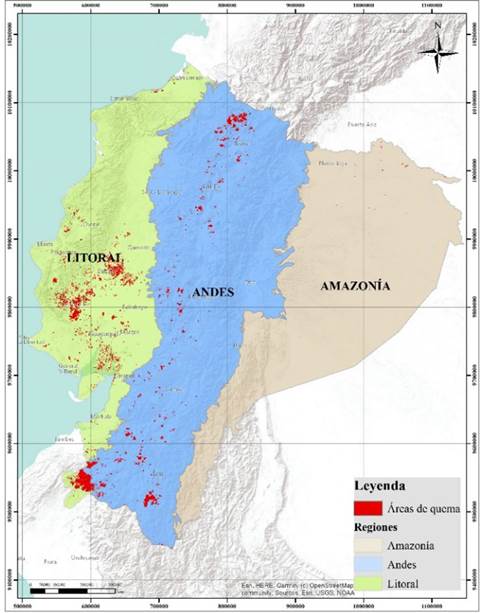
Figura 1: Área afectada por incendios (incertidumbre < 10 %) acumulada en el periodo 2001-2020 para las regiones geográficas del Ecuador continental
El SNAP del Ecuador contempla diferentes tipos de áreas protegidas. Según el Código Orgánico del Ambiente (Registro Oficial Suplemento 983 de 12-abril-2017), entre las principales categorías de manejo están: parque nacional, refugio de vida silvestre, reserva de producción de fauna, área nacional de recreación y reserva ecológica. También se analizó información para otros subsistemas del SNAP, a saber: área protegida comunitaria, área protegida privada, área protegida autónoma descentralizada, área ecológica de conservación municipal, reserva biológica, reserva geobotánica.
La información de cobertura vegetal se obtuvo del mapa CUT oficial del Ministerio del Ambiente a escala 1:100 000, y se utilizaron las seis clases del nivel 1 definido por el Grupo Intergubernamental de Expertos sobre el Cambio Climático (IPCC), a saber: bosque, vegetación arbustiva y herbácea, tierra agropecuaria, cuerpo de agua, zona antrópica y otras tierras. El análisis se enfocó en las tres primeras clases, pues son las que tienen mayor representación en superficie dentro del territorio ecuatoriano (Ministerio del Ambiente, Agua y Transición Ecológica, 2018).
La definición aplicada a la clase bosque considera la comunidad vegetal de por lo menos una hectárea de superficie, con árboles de 5 m de altura y con un mínimo de 30 % de cobertura del dosel o capa aérea vegetal. Esta definición incluye las áreas cubiertas de bambú y palmas nativas, siempre que alcancen el límite mínimo establecido en cuanto a altura y cubierta de copas. Además, excluye las formaciones de árboles utilizadas en sistemas de producción agrícola, por ejemplo, plantaciones frutales, plantaciones de palma africana y sistemas agroforestales, además de los árboles que crecen en parques y jardines urbanos (Ministerio del Ambiente, Agua y Transición Ecológica, 2017).
La clase vegetación arbustiva y herbácea se define como áreas cubiertas por arbustos y vegetación herbácea producto del proceso biológico natural -no incluye áreas agropecuarias-, mientras que la definición de tierra agropecuaria considera las áreas bajo cultivo agrícola y pastos plantados o que se encuentran dentro de una rotación entre estos (Ministerio del Ambiente, Agua y Transición Ecológica , 2017).
Análisis de datos
Para analizar los datos del producto Área Quemada MCD64A1 v6.0, se utilizó la plataforma Google Earth Engine (GEE), la cual utiliza procesamiento en la nube para el análisis geoespacial e incorpora las masivas capacidades computacionales de Google (Gorelick et al., 2017).
Dentro de la plataforma GEE, se desarrolló un script con líneas de código de programación en lenguaje JavaScript, que permitieron procesar los registros históricos de los productos Área Quemada MCD64A1 a partir de enero del 2001, año que contiene datos mensuales completos.
Las estadísticas espaciales y temporales de área de quema estimada para cada tipo de región geográfica, área protegida y cobertura vegetal se extrajeron al intersecar con las respectivas capas de información en formato vectorial cargado en la plataforma GEE. En el caso de la capa de cobertura vegetal, para acelerar el procesamiento de información, los polígonos inferiores a 5 ha se fusionaron con los polígonos adyacentes que compartían el borde de mayor longitud.
Al intersecar la información del producto MCD64A1 (resolución de 500 m), se consideró que cada píxel ocupaba la superficie de 25 ha. Esta sería una máxima superficie posible de quema. Los resultados obtenidos se deben utilizar bajo esta consideración.
El script desarrollado en GEE para la obtención de datos está estructurado de la siguiente manera. Primero, el script realiza un filtrado a la colección de imágenes MODIS/006/MCD64A1, considerando periodo entre 2001-01-01 y 2020-12-31 y una incertidumbre menor a 10. Luego, a través de iteraciones, extrae la cantidad de píxeles que se intersecan cada mes con la respectiva capa vectorial de la clase. Esto se hace en cada región, área protegida y cobertura vegetal. Después, se genera un diccionario de datos que incluye el mes correspondiente y la cantidad de píxeles o la fracción intersecada y totalizada. Cada diccionario de datos se genera individualmente para la clase de datos espaciales procesada y se exporta en formato separado por comas (*.csv). Finalmente, con ayuda del software estadístico R (R Core Team, 2022), se procesan las estadísticas básicas para cada unidad de análisis.
RESULTADOS
Para el territorio continental ecuatoriano, se evaluó la superficie total de 24 948 400 ha, excluyendo formaciones insulares cercanas al borde costero. La superficie total acumulada afectada por incendios en el período 2001-2020 fue de 729 750 ha, lo que representa el 2.9 % del territorio nacional. Es importante resaltar que la región con mayor superficie afectada por incendios fue el Litoral, con 383 770 ha que representan el 52.6 % de la superficie total de quema detectada, seguida de los Andes con 342 460 ha (46.9 %) y, con menor incidencia, la Amazonía con apenas 3 520 ha (0.5 %). En la región Litoral, las provincias con mayor superficie afectada han sido Guayas y Los Ríos y, en los Andes, las provincias de Carchi e Imbabura al Norte y la provincia de Loja al Sur (Figura 1).
En cuanto a la distribución temporal interanual de las áreas de quema, para el período de estudio a nivel nacional se detectó un valor máximo en el año 2016, con 95 593 ha. El registro de mayor porcentaje de áreas de quema fue para la región Andina (79 411 ha). A nivel de regiones, se destacan los valores máximos que se presentan en los años 2011, 2016 y 2019 para la región Andes y en 2012 y 2019 para la región Litoral (Figura 2a). Vale anotar que, para las regiones Litoral y Andes, los registros con mayor superficie se detectaron en el periodo 2010-2020.
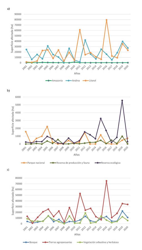
Figura 2: Análisis interanual de áreas de quema (ha) para el período 2001-2020 por a) regiones geográficas, b) tipo de área protegida y c) tipo de cobertura vegetal
El total de áreas de quema que ocurren dentro de las áreas protegidas del SNAP (35 713 ha) representa tan solo el 4.9 % del total de área de quema detectadas en el producto MCD64A1 para el período de estudio. La mayor cantidad de áreas de quema identificadas en las áreas protegidas corresponde a reservas ecológicas (19 447 ha, 54.5 %), seguido de parques nacionales (10 463 ha, 29.3 %) y reservas de producción de fauna (3904 ha, 10.9 %). El porcentaje restante (5.3 %) se distribuye entre el resto de las categorías analizadas (Figura 3). Sin embargo, si se considera el valor estandarizado de área de quema en relación con la superficie total de cada categoría de área protegida, se estima que las reservas ecológicas tienen un mayor impacto (4.4 %) si se comparan con las reservas de producción de fauna (0.5 %) y los parques nacionales (0.4 %).
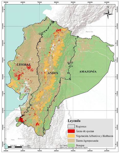
Figura 3: Área afectada por incendios en el periodo 2001-2020 para el Sistema de áreas protegidas del Ecuador continental
En cuanto al análisis interanual del comportamiento de quemas para las áreas protegidas, se observa que las reservas ecológicas y los parques nacionales presentaban tendencias relativamente similares hasta el año 2012, pero que, en adelante, hay diferencias notables; en los años 2015 y 2019, las áreas de quema de las reservas ecológicas sobrepasan notablemente a las de los parques nacionales. Por otro lado, las reservas de producción de fauna, que poseen una menor proporción de áreas de quema, presentan un solo pico en su serie temporal para el año 2019, el cual es común con las dos categorías anteriores (Figura 2b).
En lo referente a la cobertura vegetal en el Ecuador continental, se identificó que la mayor cantidad de áreas de quema total acumulada en el período de estudio se presentó en tierras agropecuarias, con 440 772 ha, casi triplicando los valores totales estimados para las clases de bosques, con 138 215 ha, y vegetación arbustiva y herbácea, con 128 116 ha (Figura 4). Si se considera el valor estandarizado para cada clase de cobertura, se puede identificar que la vegetación arbustiva y herbácea ha sufrido una afectación total del 5.4 %, mientras que las tierras agropecuarias 4.9 % y la clase bosque tan solo 1.1 %.
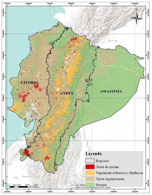
Figura 4: Área afectada por incendios en el periodo 2001-2020 para tipos de cobertura vegetal del Ecuador continental
El comportamiento interanual de las áreas de quema para el tipo de vegetación de tierra agropecuaria es similar en tendencias al que presenta la región Litoral, con picos máximos en los años 2011, 2016 y 2019. En la década 2001-2010 se presenta una tendencia similar a la región Litoral, con picos en los años 2004, 2005, 2007 y 2009, pero con valores que no se aproximan al 50 % de los presentes en los picos de la década 2010-2022 (Figura 2c).
En cuanto a los patrones intra-anuales de las áreas de quema detectados en el período de estudio, se encontró que el período de junio a diciembre cuenta con más áreas de quema en el territorio ecuatoriano (Figura 5). Los meses de septiembre, noviembre y diciembre presentan una mayor acumulación de áreas totales de quema, y septiembre y diciembre muestran la mayor frecuencia de picos de área total de quema. Sobresalen los meses de noviembre del 2011 y del 2016 como extremos.
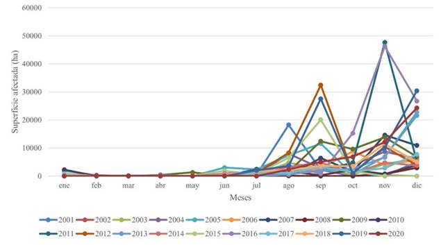
Figura 5: Superficies de quema totales mensuales para el Ecuador continental en el período 2001-2020
DISCUSIÓN
Para el Ecuador continental, no se ha establecido una base de datos robusta y de larga temporalidad sobre la ocurrencia de incendios (Pazmiño, 2019). Además, la literatura científica respecto al tema de incendios forestales es reducida, lo cual se evidencia en artículos de revisión (Armenteras et al., 2020). Entre los pocos esfuerzos mayormente publicados en revistas locales, se encuentra el estudio de Pazmiño (2019), que analiza un índice de peligrosidad de incendios para la región Andina ecuatoriana, así como otros estudios de tipo local realizados a nivel del Distrito Metropolitano de Quito (Columba et al., 2016) o para el cantón Loja (Reyes-Bueno & Balcazar-Gallegos, 2021; Reyes-Bueno & Loján-Córdova, 2022).
En cuanto a datos oficiales, en el Ecuador existen los reportes periódicos de la Secretaría de Gestión de Riesgos, que recolecta información en conjunto con el cuerpo de bomberos y brigadas de refuerzo, actuando con base en los sistemas de alerta (Servicio Nacional de Gestión de Riesgos y Emergencias, 2020). Sin embargo, la información recopilada en los últimos 20 años no está sistematizada. Los resultados de este estudio indican que las provincias de la región Litoral Guayas, Los Ríos y Manabí presentaron la mayor incidencia de áreas de quema. Asimismo, a lo largo de la región Andes se presentaron zonas críticas. Estos resultados podrían ser contrapuestos con la base de datos de la Secretaría de Gestión de Riesgos en aras de corroborarlos. Cabe añadir que la región Amazonía registró una incidencia de incendios muy baja.
Algunos autores han relacionado el incremento de la ocurrencia de incendios con el aumento de períodos de sequía (Malhi et al., 2009). Si bien es un dato preliminar, el análisis interanual de áreas de quema realizado para el Ecuador continental indica que, a partir del año 2010, estas superficies tienden a aumentar (Figura 2a). Esta observación plantea incertidumbres para analizar otras variables como la variabilidad climática inter e intra-anual (Armenteras et al., 2011; Celi Díaz et al., 2023). Otras variables que influyen en la ocurrencia de incendios, como la topografía, la carga de combustible y la actividad antrópica han sido poco estudiadas en los ecosistemas del Ecuador. Entre los pocos estudios realizados está el de Reyes-Bueno & Balcázar-Gallegos (2021), en el cual se identificó la distancia a zonas antrópicas como la variable más importante en un modelo de susceptibilidad a incendios forestales para el cantón Loja. Entre otras variables reportadas como relevantes, Reyes-Bueno & Balcázar-Gallegos (2021) señalan la temperatura mínima y la precipitación en el trimestre más seco. Un reciente estudio realizado por Celi Díaz et al. (2023) incorpora de una manera muy original el conocimiento ancestral del manejo del fuego del pueblo indígena Kichwa-Saraguro del sur del Ecuador, en combinación con variables climáticas y la severidad de los incendios, para comprender mejor el uso tradicional del fuego en el manejo de ecosistemas. Al ser la región Litoral y las tierras agropecuarias las más afectadas históricamente en el periodo de estudio, sería interesante investigar cuáles son los usos del fuego en las prácticas agropecuarias de estas zonas y cuál es su posible influencia en la extensión de áreas quemadas detectadas.
En el análisis de las áreas protegidas se evidencia una tendencia similar al comportamiento interanual detectado para las tres regiones, con un notable incremento de áreas de quema a partir del 2010, sobre todo para las reservas ecológicas, que, al representar menor superficie, proporcionalmente reciben un mayor impacto. En términos generales, la categoría de reserva de producción de fauna es la que ha tenido menor incidencia de áreas de quema, lo cual puede deberse al pequeño número de áreas de esta categoría (4). La de mayor extensión es la Reserva de Protección de Fauna del Cuyabeno, que se encuentra al norte de la Amazonía ecuatoriana, región que coincide con la poca presencia de áreas de quema detectadas por el producto MCD64A1. Una explicación para esto tiene que ver con las condiciones climáticas del noroeste de la cuenca amazónica, con precipitaciones anuales promedio mayores de los 3000 mm y con muy poco estrés hídrico estacional, incluso en años secos (Malhi et al., 2009). Esto ha condicionado la ocurrencia de incendios forestales, diferenciándola del resto de la Amazonía, que tiene patrones de incendios distintos y más influenciados por sequías (Armenteras & Retana, 2012; Marengo et al., 2008)
Los parques nacionales, categoría que ocupa la mayor superficie de área protegida (aproximadamente 3 068 076 ha, excluyendo el Parque Nacional Galápagos), han presentado un valor total relativamente menor de afectación en todo el período de estudio, representando el 0.3 % del área. A escala nacional, se puede apreciar que las áreas de quema detectadas están alejadas de los sitios donde se concentran la mayoría de las áreas protegidas (Figura 3). De alguna manera, el bajo porcentaje de incidencia podría vincularse a la presencia de áreas protegidas, relación que ha sido estudiada por otros autores (Catarino et al., 2020; Walker et al., 2020) y que podría influenciar este comportamiento.
En cuanto a los tipos de cobertura vegetal analizados, en valores absolutos, la clase tierras agropecuarias ha presentado la mayor cantidad de áreas de quema. Sin embargo, en porcentajes relativos al área total que ocupan, la vegetación arbustiva y herbácea es la clase que más se vio afectada en el período de estudio. Este tipo de cobertura es muy importante a nivel nacional, ya que engloba una gran proporción del ecosistema páramo andino, que es muy importante para la provisión de servicios ecosistémicos en la región Andes, y a la vez muy vulnerable a los incendios forestales. La clase bosque tiene menor impacto (1.1 %), lo cual se debe a que la región Amazonía que posee la mayor extensión de bosque y la menor extensión de áreas de quema. Vale recalcar que la región Amazonía ecuatoriana está ubicada al noroeste de la cuenca amazónica zona, que contrasta con las condiciones climáticas y los regímenes de incendios de las zonas central, sur y sureste, que en mayor proporción cubren el territorio de Brasil (Carvalho et al., 2021; Malhi et al., 2009). En el estudio de Armenteras & Retana (2012), por ejemplo, se resaltan años de fuerte sequía como el 2005 y el 2010, para los cuales el noroeste de la Amazonía presentó bajo número de puntos calientes de incendios. Incluso, el 2005 fue uno de los años más húmedos, mientras que en la Amazonía brasileña la sequía favoreció en la ocurrencia de incendios (Marengo et al., 2008). Además, se debe considerar las actividades humanas diferenciadas en estos sectores. En Brasil se relacionan los incendios con la agricultura industrial de gran escala (Brando et al., 2013), así como con el manejo de pastos (Cano-Crespo et al., 2015). En el noroeste de la Amazonía, en cambio, se han identificado actividades en las que se utiliza el fuego como principal herramienta, tales como la deforestación, la agricultura de pequeña escala, la crianza de ganado y la ampliación de fronteras agrícolas (Armenteras & Retana, 2012).
En el análisis realizado por Armenteras et al. (2020), se identifica que el bioma más afectado para el Ecuador son los bosques húmedos tropicales y subtropicales. La explicación para estas diferencias radica en que la clasificación utilizada para dicha investigación utiliza la clasificación de ecorregiones a escala global presentada por Olson et al. (2001). Sin embargo, en un análisis comparativo visual se puede apreciar que las áreas de mayor densidad de quema detectadas por Armenteras et al. (2020) en el período 2001-2018 coinciden espacialmente con el principal foco de áreas de quema, ubicado en la provincia del Guayas para este estudio y que sucede sobre la clase tierras agropecuarias (Figura 4).
Las tendencias interanuales detectadas en la región Litoral son muy similares a las tendencias identificadas en las afectaciones del tipo de vegetación de tierra agropecuaria, lo que podría indicar que el manejo de estas áreas está marcando el comportamiento de la región para la época de estudio. Sin embargo, este hecho necesita ser investigado a mayor profundidad, analizando por ejemplo la variabilidad climática inter e intra-anual en la región, así como la severidad de los incendios, los factores socioeconómicos y las prácticas de manejo del fuego que se utilizan en estas zonas.
CONCLUSIONES
Para el Ecuador continental, se ha identificado que la región Litoral presenta una mayor superficie total de áreas de quema con, 383 773 ha, seguida de los Andes con 342 463 ha. La región Amazonía es la de menor incidencia de quemas. También se detectó que las reservas ecológicas son la categoría de áreas protegidas que presentan más afectación total por áreas de quema de manera acumulada. Las tierras agropecuarias y la vegetación arbustiva y herbácea son las clases de cobertura vegetal que tienen mayor incidencia histórica de áreas de quema en relación con su superficie. Estas áreas representan alrededor del 5 % de su superficie total. Este estudio es una guía inicial que pretende llenar un vacío de información en la literatura en lo referente a incendios de áreas naturales para el Ecuador continental. Los resultados obtenidos son útiles para el diseño de políticas y regulaciones relacionadas con el manejo del fuego a nivel nacional y local, y pueden aportar a la Estrategia Nacional para el Manejo Integrado del Fuego 2021-2025 propuesta por el Ministerio de Ambiente, Agua y Transición Ecológica de Ecuador.
Acknowledgements
AGRADECIMIENTOS
Los autores agradecen a Sara Tenorio por el apoyo en el desarrollo de la cartografía del manuscrito.
REFERENCIAS


Licencia
Derechos de autor 2024 Colombia forestal

Esta obra está bajo una licencia internacional Creative Commons Atribución-CompartirIgual 4.0.
Colombia Forestal conserva los derechos patrimoniales (copyright) de las obras publicadas, y favorece y permite la reutilización de las mismas bajo la licencia Creative Commons Atribución-CompartirIgual 4.0 Internacional por lo cual se pueden copiar, usar, difundir, transmitir y exponer públicamente, siempre que:
Se reconozcan los créditos de la obra de la manera especificada por el autor o el licenciante (pero no de una manera que sugiera que tiene su apoyo o que apoyan el uso que hace de su obra).